Cumberland Township near Gettysburg in Adams County, Pennsylvania — The American Northeast (Mid-Atlantic)
First Corps
Army of the Potomac
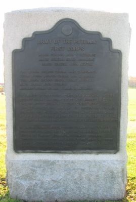
Inscription.
First Corps
Major General John F. Reynolds
Major General Abner Doubleday
Major General John Newton
Second Division Brigadier General John C. Robinson
Third Division Brigadier General Thomas A. Rowley, Major General Abner Doubleday
Artillery Brigade Colonel Charles S. Wainwright
July 1. Arrived at Gettysburg between 10 a.m. and noon. Relieved Buford's Cavalry and became engaged with Archer's and Davis's Brigades Heth's Division Hill's Corps. General Reynolds fell mortally wounded about 10.15 a.m. The Confederates having been reinforced from Hill's and Ewell's Corps made a vigorous attack at 2 p.m. with superior numbers along the entire line. At 4 p.m. the Corps retired and took positions on Culp's Hill and Cemetery Ridge.
July 2 & 3 Wadsworth's Division occupied the north part of Culp's Hill connecting with 12th Corps on right and Robinson's and Rowley's Divisions on Cemetery Ridge with detachments elsewhere.
Casualties including Corps and Division staff killed 42 officers, 624 men. Wounded 262 officers, 2969 men. Captured or missing 83 officers, 2079 men. Total 6059.
Erected 1906 by Gettysburg National Military Park Commission.
Topics. This historical marker is listed in this topic list: War, US Civil. A significant historical month for this entry is July 1833.
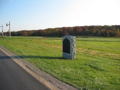
Location. 39° 50.166′ N, 77° 14.953′ W. Marker is near Gettysburg, Pennsylvania, in Adams County. It is in Cumberland Township. Marker is at the intersection of Reynolds Avenue and Chambersburg Pike (U.S. 30), on the right when traveling north on Reynolds Avenue. Located on the First Day Battlefield, north of McPherson Woods, in Gettysburg National Military Park. Touch for map. Marker is in this post office area: Gettysburg PA 17325, United States of America. Touch for directions.
Other nearby markers. At least 8 other markers are within walking distance of this marker. 8th Illinois Cavalry (within shouting distance of this marker); 143d Pennsylvania Infantry (within shouting distance of this marker); 1st Corps Headquarters (within shouting distance of this marker); First Division (about 300 feet away, measured in a direct line); a different marker also named First Division (about 400 feet away); 12th Illinois Cavalry (about 400 feet away); First Brigade (about 500 feet away); 6th Wisconsin Volunteers (about 600 feet away). Touch for a list and map of all markers in Gettysburg.
Also see . . . Reports of Maj. Gen. Abner Doubleday. As General Reynolds was commanding a "Wing" of the Army of the Potomac (the I, III, and XI Corps), General Doubleday assumed command
of the Corps. Of the initial lines of battle, Doubleday wrote:
A small piece of woods cut the line of battle in about two equal parts. These woods possessed all the advantages of a redoubt, strengthening the center of our line, and enfilading the enemy's columns should they advance in the open spaces on either side. I deemed the extremity of the woods, which extended to the summit of the ridge, to be the key of the position, and urged that portion of Meredith's brigade, the Western men assigned to its defense, to hold it to the last extremity. Full of the memory of their past achievements, they replied cheerfully and proudly, "If we can't hold it, where will you find men who can?" General Reynolds' intention appeared to be simply to defend the two roads entering the town from the northwest and southwest, and to occupy and hold the woods between them. The principal effort of the enemy was made on the Cashtown road from the northwest, and was opposed at first by Cutler's brigade and Hall's battery, the former stretching across, the latter posted on, the right of the road. (Submitted on January 11, 2009, by Craig Swain of Leesburg, Virginia.)

Photographed By Craig Swain, November 1, 2008
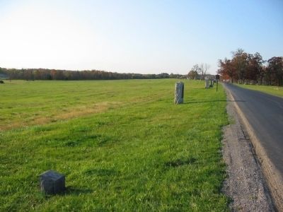
3. McPherson Ridge
Looking south past the tablet at Reynolds Avenue. McPherson Woods, where Reynolds was killed, is on the right in the distance. This road did not exist at the time of the battle, but was laid out during the early days of the park to allow visitors to trace the First Corps battle line from Fairfield Road (south) to Chambersburg Pike.

Photographed By Craig Swain, November 1, 2008
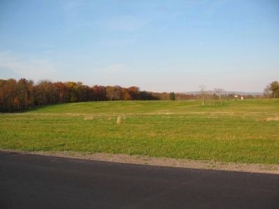
4. McPherson Woods and the I Corps Line
As General Doubleday mentioned in his report, McPherson Woods do help form a "salient" in the center of the federal lines. Looking at the ground just north of the woods, the clear ground leaves any attacker open for flanking fires. Eventually, the Confederates had to reduce the defensive line of Meredith's Iron Brigade in those woods in order to push the First Corps off the ridge. However, in all fairness, Doubleday probably overstated the importance of the woods within the tactical context. As the battle developed, the position was nearly isolated.
Credits. This page was last revised on February 7, 2023. It was originally submitted on January 11, 2009, by Craig Swain of Leesburg, Virginia. This page has been viewed 1,063 times since then and 21 times this year. Photos: 1, 2, 3, 4. submitted on January 11, 2009, by Craig Swain of Leesburg, Virginia.

