Cumberland Township near Gettysburg in Adams County, Pennsylvania — The American Northeast (Mid-Atlantic)
End of the First Day
July 1, 1863 - First Day
Gen. Robert E. Lee, C.S.A.
Commander, Army of Northern Virginia
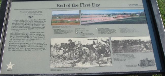
Infantry and artillery of the Union Eleventh Corps formed in the valley below you on the afternoon of July 1 to defend against Rodes' and Early's Confederate divisions which were attacking them from your left and rear. By 4:00 p.m. the Confederate tide swept through this area, scooping up 3,000 Union prisoners on the way.
9,000 Union soldiers and 6,800 Confederate soldiers were killed, wounded, or missing on July 1. Both sides paid a heavy price, but the Southerners had won the day. Gen. Robert E. Lee, the Confederate commander, believed his gains here gave hope for victory.
The Federals retreated through the streets of Gettysburg to Cemetery Hill and Culp's Hill just south and east of town. Despite their defeat the first day, they held a strong defensive position from which to renew the fight the following day.
(Key points indicated in photographs):
(1) Barlow Knoll
Maj. Gen. Jubal Early's Confederates smashed Union defenders here on the afternoon of July 1, leading to the collapse of the Union line.
(2) Carlisle Road
(3) Mummasburg Road
(4) Culp's Hill
Retreating Federals occupied this strategic high ground on the evening of July 1.
(5) Gettysburg College
Known as Pennsylvania College in 1863, it served as a hospital during and after the battle. Both armies posted lookouts in the cupola on the roof of the main building.
(5) Cemetery Hill
Union troops who survived the rout north of town rallied here on the evening of July 1 with the reserve troops of Maj. Gen. Oliver O. Howard
Erected by Gettysburg National Military Park.
Topics. This historical marker is listed in this topic list: War, US Civil. A significant historical date for this entry is July 1, 1863.
Location. Marker has been permanently removed. It was located near 39° 50.639′ N, 77° 14.515′ W. Marker was near Gettysburg, Pennsylvania, in Adams County. It was in Cumberland Township. Marker was on Doubleday Avenue, on the left when traveling south. Located next to the observation tower on the Oak Ridge section of Gettysburg National Military Park. Touch for map. Marker was in this post office area: Gettysburg PA 17325, United States of America.
We have been informed that this sign or monument is no longer there and will not be replaced. This page is an archival view of what was.
Other nearby markers. At least 8 other markers are within walking distance of this location. Sacrifice of the 16th Maine (here, next to this marker); 12th Massachusetts Volunteers (within shouting distance of this marker); 90th Pennsylvania Volunteers (within shouting distance of this marker); John Cleveland Robinson (within shouting distance of this marker); 16th Maine Infantry (within shouting distance of this marker); 88th Pennsylvania Infantry (within shouting distance of this marker); 104th New York Infantry (about 300 feet away, measured in a direct line); 88th Pennsylvania Volunteers (about 300 feet away). Touch for a list and map of all markers in Gettysburg.
More about this marker. In the upper center and right of the marker are a set of photos showing key points north of and in Gettysburg. You are standing on Oak Ridge looking east and south toward Gettysburg. You are one mile from the center of town.
In the lower center, This illustration of Union infantrymen by Gilbert Gaul gives a good impression of what it must have been like here on the first day.
In the right center, This 1880s photo taken from this ridge shows how Gettysburg may have looked to an attacking Confederate. The large building at center is Pennsylvania College (now Gettysburg College), and behind it to the left, Culp's Hill. Below the photo is a drawing
of Pennsylvania College (Gettysburg College).
Related markers. Click here for a list of markers that are related to this marker. Oak Ridge markers and memorials.

Photographed By Craig Swain
4. Looking Southeast from the Tower
(Double click image to zoom.)
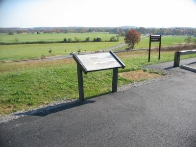
The town of Gettysburg has grown out considerably since the time of the battle. Baseball fields cover open ground that the Federals retreated across during the battle. Note the photos on the marker show a large tower behind Cemetery Hill. The tower was removed in in 2000.
The town of Gettysburg has grown out considerably since the time of the battle. Baseball fields cover open ground that the Federals retreated across during the battle. Note the photos on the marker show a large tower behind Cemetery Hill. The tower was removed in in 2000.
Credits. This page was last revised on May 27, 2023. It was originally submitted on January 18, 2009, by Craig Swain of Leesburg, Virginia. This page has been viewed 1,500 times since then and 67 times this year. Photos: 1, 2, 3, 4. submitted on January 18, 2009, by Craig Swain of Leesburg, Virginia.


