Cumberland Township near Gettysburg in Adams County, Pennsylvania — The American Northeast (Mid-Atlantic)
Images of Death
July 2, 1863 - Second Day
"It was now near nightfall, and the operations of the day were over. …I commenced the melancholy task of looking up my numerous dead and wounded. It was a sad list."
Brig. Gen. J.B. Kershaw, C.S.A.
Kershaw's Brigade, McLaws' Division
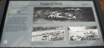
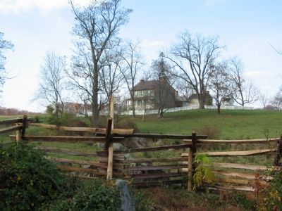
In 1863 this land was farmed by John Rose who lived in the stone house visible in front of you.
On the afternoon of July 2, Georgians and South Carolinians of Anderson's, Semmes', and Kershaw's Brigades advanced and retreated across this ground in their bloody assaults on the Wheatfield, located just beyond the woods behind you. Many Confederate soldiers fell here, the grim harvest of Union riflemen and artillerists.
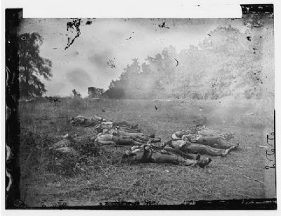
The photographs in this exhibit are from a series of ten views taken here on the Rose Farm by Civil War photographer Alexander Gardner on July 5, 1863. The bloated bodies are unknown Confederate soldiers. They had been dead for three days.
Erected by Gettysburg National Military Park.
Topics. This historical marker is listed in this topic list: War, US Civil. A significant historical date for this entry is July 2, 1787.
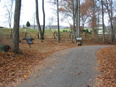
Location. This marker has been replaced by another marker nearby. It was located near 39° 47.745′ N, 77° 14.859′ W. Marker was near Gettysburg, Pennsylvania, in Adams County. It was in Cumberland Township. Marker was on Brooke Avenue, on the left when traveling north. Located in the Rose Woods, a short distance from the Avenue, in Gettysburg National Military Park. Touch for map. Marker was in this post office area: Gettysburg PA 17325, United States of America. Touch for directions.
Other nearby markers. At least 8 other markers are within walking distance of this location. Capturing the Carnage (here, next to this marker); Kershaw's Brigade (a few steps from this marker); 145th Pennsylvania Infantry (within shouting distance of this marker); 27th Connecticut Infantry (within shouting distance of this marker); 27th Regiment Connecticut Volunteers Position (within shouting distance of this marker); 53rd Pennsylvania Infantry (about 300 feet away, measured in a direct line); Semmes's Brigade (about 300 feet away); Fourth Brigade (about 300 feet away). Touch for a list and map of all markers in Gettysburg.
More about this marker. In the upper part of the marker is a Historic photo taken on this farm July 5, 1863, three days after the Confederates pictured had been killed. In the lower center is another of Gardner's photos. The photographer found these fifteen corpses laid out in a "V". Confederate comrades probably collected the bodies, but were forced to abandon them when they retreated July 4. Union soldiers were left the task of burial. In the lower right is Another of Alexander Gardner's views of the battlefield dead taken along the edge of these woods. Note the photographer's wagon (upper left) where the glass plate negatives were developed.
Related markers. Click here for a list of markers that are related to this marker. Ayres, Cross, and Brooke Avenues Virtual tour by Markers
Also see . . . New marker at this location titled Capturing the Carnage. (Submitted on April 21, 2022.)

3. Another of Gardner's Photos
Another view of the "V" arrangement of Confederate bodies.
(Civil War photographs, 1861-1865 / compiled by Hirst D. Milhollen and Donald H. Mugridge, Washington, D.C. : Library of Congress, 1977. No. 0201)
Click for more information.
(Civil War photographs, 1861-1865 / compiled by Hirst D. Milhollen and Donald H. Mugridge, Washington, D.C. : Library of Congress, 1977. No. 0201)
Click for more information.
Credits. This page was last revised on February 26, 2023. It was originally submitted on January 26, 2009, by Craig Swain of Leesburg, Virginia. This page has been viewed 1,256 times since then and 16 times this year. Photos: 1, 2, 3, 4. submitted on January 26, 2009, by Craig Swain of Leesburg, Virginia.


