Near Chester in Chesterfield County, Virginia — The American South (Mid-Atlantic)
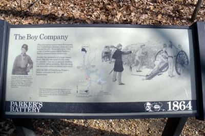
The Boy Company
Parker's Battery 1864
Despite the proximity of a large enemy force, this line was quiet for the next 9˝ months-just an occasional shelling, or pickets taking potshots. The shooting war was a few miles northeast and south.
After the fall of Petersburg, Parker’s Battery retreated with Lee to Appomattox.
Erected by Richmond National Battlefield Park - National Park Service.
Topics. This historical marker is listed in this topic list: War, US Civil. A significant historical year for this entry is 1864.
Location. This marker has been replaced by another marker nearby. 37° 20.989′ N, 77° 23.67′ W. Marker is near Chester, Virginia, in Chesterfield County. Marker can be reached from Ware Bottom Spring Road, 0.1 miles east of Old Stage Road, on the right. This marker is located within the Parker’s Battery Unit of the Richmond National Battlefield Park. Touch for map. Marker is at or near this postal address: 1801 Ware Bottom Spring Road, Chester VA 23836, United States of America. Touch for directions.
Other nearby markers. At least 8 other markers are within walking distance of this location. A different marker also named Boy Company (here, next to this marker); Parker’s Battery (within shouting distance of this marker); Howlett Line (within shouting distance of this marker); a different marker also named Howlett Line (within shouting distance of this marker); a different marker also named Parker’s Battery (about 500 feet away, measured in a direct line); a different marker also named Parker's Battery (about 500 feet away); Remembrance (about 500 feet away); Battery Dantzler (approx. 0.3 miles away). Touch for a list and map of all markers in Chester.
More about this marker. On the left is a photo of "A young artillerist. Many of Dr. William W. Parker’s cannoneers were between the ages of fourteen and nineteen. They became known as “The Boy Company,” although the average age was twenty- five."
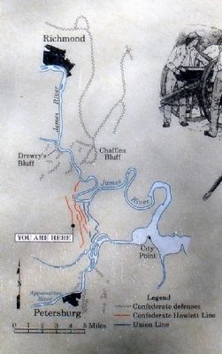
On the center is a map of the Howlett Line with the caption, "These Confederate entrenchments were thrown up to block Butler’s troops after failure of the Federal attack on Drewry’s Bluff. The Howlett Line connected Richmond’s defenses with Petersburg’s."
Related marker. Click here for another marker that is related to this marker. New Marker At This Location titled "Boy Company".
Credits. This page was last revised on November 4, 2021. It was originally submitted on February 12, 2009, by Bernard Fisher of Richmond, Virginia. This page has been viewed 1,330 times since then and 14 times this year. Last updated on January 10, 2021, by Bradley Owen of Morgantown, West Virginia. Photos: 1, 2, 3. submitted on February 12, 2009, by Bernard Fisher of Richmond, Virginia.


