West Ashley in Charleston in Charleston County, South Carolina — The American South (South Atlantic)
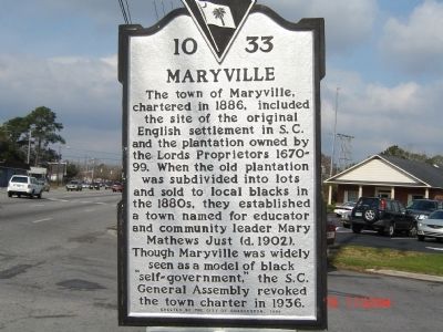
Maryville
Erected 1999 by City of Charleston. (Marker Number 10-33.)
Topics. This historical marker is listed in these topic lists: African Americans • Agriculture • Colonial Era • Education • Settlements & Settlers • Women. A significant historical year for this entry is 1886.
Location. 32° 47.706′ N, 79° 59.58′ W. Marker is in Charleston, South Carolina, in Charleston County. It is in West Ashley. Marker is at the intersection of Saint Andrews Boulevard and 5th Avenue, on the right when traveling north on Saint Andrews Boulevard. Touch for map. Marker is in this post office area: Charleston SC 29407, United States of America. Touch for directions.
Other nearby markers. At least 8 other markers are within walking distance of this marker. Mixed Results (approx. 0.7 miles away); Ship Shaping (approx. 0.7 miles away); Seized! (approx. 0.7 miles away); Harnessing the Wind (approx. 0.7 miles away); 300th Anniversary of the Settlement of Charles Towne (approx. 0.7 miles away); The Adventure, Trading Ketch (approx. 0.7 miles away); Stained Dirt?! (approx. 0.7 miles away); Hints of Slave Row (approx. 0.7 miles away). Touch for a list and map of all markers in Charleston.
Credits. This page was last revised on February 16, 2023. It was originally submitted on February 19, 2009, by Michael Sean Nix of Spartanburg, South Carolina. This page has been viewed 2,011 times since then and 63 times this year. Photo 1. submitted on February 19, 2009, by Michael Sean Nix of Spartanburg, South Carolina. • Kevin W. was the editor who published this page.
