Downtown in Columbus in Franklin County, Ohio — The American Midwest (Great Lakes)
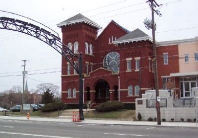
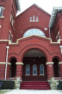
St. Paul African Methodist Episcopal Church
Inscription.
Organized in 1823 as Bethel African Methodist Episcopal Church, St. Paul A.M.E. Church is the oldest congregation of African descent in Columbus. The church, founded by Moses Freeman and 13 other members from the Town Street Church, was originally located on the east side of Lazelle Street. Several buildings were erected to meet the needs of the growing congregation. The present edifice, located at 639 E. Long Street, was completed in 1906. St. Paul has several outreach ministries, including The Prison Ministry, Alzheimer Ministry, Karenís House, Community Development Corporation, Health Concerns Committee, St. Paul Tutorial and Enrichment Program (STEP), St. Paul Scholarship Program, St. Paul Drama Ministry, JamíN Jefferson Park Festival, and Church Without Walls.
Erected 2003 by St. Paul A.M.E. Church and The Ohio Historical Society. (Marker Number 68-25.)
Topics and series. This historical marker is listed in these topic lists: African Americans • Charity & Public Work • Churches & Religion • Science & Medicine • Settlements & Settlers. In addition, it is included in the African Methodist Episcopal (AME) Church, and the Ohio Historical Society / The Ohio History Connection series lists. A significant historical year for this entry is 1823.
Location. 39° 58.004′ N, 82° 59.067′ W. Marker is in Columbus, Ohio, in Franklin County. It is in Downtown. Marker is at the intersection of Long Street and Jefferson Avenue, on the right when traveling east on Long Street. Touch for map. Marker is at or near this postal address: 639 E Long Street, Columbus OH 43215, United States of America. Touch for directions.
Other nearby markers. At least 8 other markers are within walking distance of this marker. King Lincoln District Arch (here, next to this marker); James Thurber (about 300 feet away, measured in a direct line); Donn Vickers Gazebo in Thurber Park (about 500 feet away); Elijah Pierce (about 800 feet away); The Lincoln Theatre (approx. 0.2 miles away); Wesley Chapel Methodist Church (approx. 0.3 miles away); Home Site of Henry Howe ó Historian (approx. 0.3 miles away); Shiloh Baptist Church (approx. 0.3 miles away). Touch for a list and map of all markers in Columbus.
Credits. This page was last revised on February 3, 2023. It was originally submitted on March 12, 2009, by William Fischer, Jr. of Scranton, Pennsylvania. This page has been viewed 3,040 times since then and 121 times this year. Photos: 1, 2, 3. submitted on March 12, 2009, by William Fischer, Jr. of Scranton, Pennsylvania. • Christopher Busta-Peck was the editor who published this page.


