Pawleys Island in Georgetown County, South Carolina — The American South (South Atlantic)
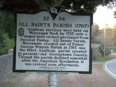
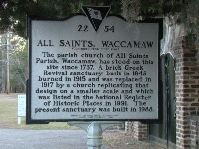
All Saints Parish (1767) / All Saints, Waccamaw
The parish church of All Saints Parish, Waccamaw, has stood on this site since 1737. A brick Greek Revival sanctuary built in 1843 burned in 1915 and was replaced in 1917 by a church replicating that design on a smaller scale and which was listed in the National Register of Historic Places in 1991. The present sanctuary was built in 1988.
Erected 2001 by the Pee Dee Chapter, National Society Colonial Dames XVII Century. (Marker Number 22-54.)
Topics and series. This historical marker is listed in this topic list: Churches & Religion. In addition, it is included in the The Colonial Dames XVII Century, National Society series list. A significant historical year for this entry is 1737.
Location. 33° 28.044′ N, 79° 8.367′ W. Marker is on Pawleys Island, South Carolina, in Georgetown County. Marker is on Kings River Road (Local Route 22-255) north of Waverly Road (Local Route 22-449 ), on the left when traveling north. Touch for map. Marker is in this post office area: Pawleys Island SC 29585, United States of America. Touch for directions.
Other nearby markers. At least 8 other markers are within 4 miles of this marker, measured as the crow flies. St. John A.M.E. Church (approx. 1.4 miles away); School House (approx. 1.9 miles away); Waverly Building (approx. 1.9 miles away); Pawley’s Island / Waccamaw Neck (approx. 2.6 miles away); Pawleys Island House of Worship (approx. 2.9 miles away); R.F.W. Allston Causeway (approx. 3.1 miles away); R. F. W. Allston House (approx. 3.3 miles away); Joseph & Theodosia Burr Alston (approx. 3.4 miles away). Touch for a list and map of all markers in Pawleys Island.
Credits. This page was last revised on November 15, 2020. It was originally submitted on March 14, 2009, by J. J. Prats of Powell, Ohio. This page has been viewed 2,723 times since then and 62 times this year. Photos: 1, 2, 3. submitted on March 14, 2009, by J. J. Prats of Powell, Ohio.


