Near Chester in Chesterfield County, Virginia — The American South (Mid-Atlantic)
Bermuda Hundred
Captain John Smith’s Adventures on the James
— www.johnsmithtrail.org —
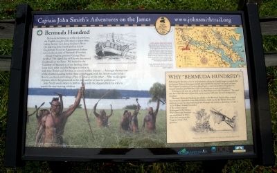
Future Virginia governor George Percy recalled: “The eighth day of May we discovered [explored] up the River. We landed in the Countrey of Apamatica, at our landing, there came many stout and able Savages to resist us with their Bowes and Arrowes, in a most warlike manner …Amongst the rest one of the chiefest standing before them crosselegged, with his Arrow readie in his Bow in one hand, and taking a Pipe of Tobacco in the other …Wee made signes of peace, which they perceived in the end, and let us land in quietnesse.”
John Smith would return in 1608 to trade with the Appamattuck for corn to sustain the near-starving colonists.
Capt. John Smith’s Trail
John Smith knew the James River by its Algonquian name: Powhatan, the same as the region’s paramount chief. Smith traveled the river many times between 1607 and 1609, trading with Virginia Indians to ensure survival at Jamestown. What he saw of Virginia’s verdant woodlands and pristine waters inspired him to explore the greater Chesapeake Bay, chronicling its natural wonders.
(sidebar)
Why “Bermuda Hundred”?
Following the first lean years of the Jamestown colony, the English began to expand their settlements. Tobacco farming promised great wealth but required both land and labor. The Virginia Company of London offered land – a rare commodity in England – to intrepid investors, provided they could recruit laborers to work the plantations.
Echoing an old term for political units, these farms were called “hundreds.” The name may have stuck because a plantation owner received 100 acres for each immigrant he recruited.
The name Bermuda Hundred also alludes to the Bermuda Islands, where a supply ship bound for Jamestown was shipwrecked in 1609. Led by Sir Thomas Gates, the survivors escaped in ships built from the wreckage and arrived at Jamestown on June 7, 1610. William Strachey’s account of the ordeal inspired Shakespeare’s The Tempest. When Bermuda Hundred was established in 1613, Gates was serving as the Virginia colony’s 3rd governor.
Erected by Captain John Smith’s Trail, James River Association, Virginia Department of Conservation and Recreation, Chesapeake Bay Gateways Network. (Marker Number 13.)
Topics. This historical marker is listed in these topic lists: Colonial Era • Exploration • Native Americans • Settlements & Settlers. A significant historical month for this entry is June 1861.
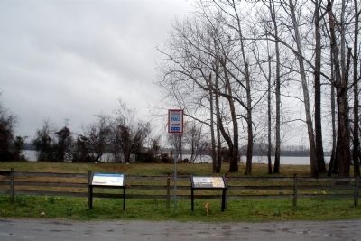
Location. 37° 20.486′ N, 77° 16.279′ W. Marker is near Chester, Virginia, in Chesterfield County. Marker is on Bermuda Hundred Road, 1.4 miles east of Allied Road, on the right when traveling east. Touch for map. Marker is in this post office area: Chester VA 23836, United States of America. Touch for directions.
Other nearby markers. At least 8 other markers are within 2 miles of this marker, measured as the crow flies. A different marker also named Bermuda Hundred (a few steps from this marker); Bermuda Hundred Landing (within shouting distance of this marker); Beyond the Big House (approx. 1.7 miles away); Resistance and Punishments (approx. 1.7 miles away); A Busy Port (approx. 1.7 miles away); Grant's Cabin (approx. 1.7 miles away); City Point (approx. 1.7 miles away); a different marker also named City Point (approx. 1.7 miles away). Touch for a list and map of all markers in Chester.
More about this marker. On the upper left is a sketch of an English shore party with the caption, “Drawing by Marc Castelli for John Smith Four Hundred Project © 2006.”
On the lower left is a depiction of Native Americans reacting to the English landing party. The photo carries the caption, “The New World” © MMV, New Line Productions, Inc. All rights reserved. Photo by Merie Wallace. Photo appears courtesy of New Line Productions, Inc.”
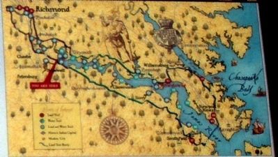
On the upper right is a map Captain John Smith's Trail. The map carries the caption, “Capt. John Smith’s Trail on the James is a 40-site water trail and auto tour for modern explorers.”
On the right of the sidebar is a sketch of an English ship with the caption, “Drawing by Marc Castelli E.W. Haile’s book, Where None Hath Stood Before © 2006.”
Also see . . .
1. Captain John Smith’s Trail. (Submitted on March 17, 2009.)
2. Wikipedia. Bermuda Hundred, Virginia. (Submitted on March 17, 2009.)
Credits. This page was last revised on November 4, 2021. It was originally submitted on March 17, 2009, by Bernard Fisher of Richmond, Virginia. This page has been viewed 2,828 times since then and 38 times this year. Photos: 1, 2, 3. submitted on March 17, 2009, by Bernard Fisher of Richmond, Virginia.


