Cumberland in Allegany County, Maryland — The American Northeast (Mid-Atlantic)
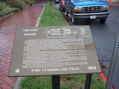
The Fort Proper
Fort Cumberland Trail
Additional barracks were built to your right (out to Smallwood Street) for the extra men sometimes here. Temporary earthworks were built on the hill northwest of you for added protection. Dress parades were held to your right on the grand parade ground (courthouse and library grounds). There, in 1794, President Washington reviewed troops gathered to put down the Whiskey Rebellion. The Sabbath was observed and religious services were held by the chaplains of the regiments. Pay for some Maryland troops was 8 pence (8¢) per day for privates plus clothes, arms, etc. The main gate (MG) was located near the side wall (midway down) of the present brick building to your left.
The Commissary House (10) was located across the street to the left and behind you. Soldiers serving as bakers for Mr. Lake, Commissary of Provisions for General Braddock, were relieved of other duties. The commissary kept the army fed. Each man on picket duty was allowed 1 gill (¼ pint) liquor spirits mixed with 3 gills of water per day.
One of the tunnels leading from the fort came out in the basement of the library building across the square behind and to your right. Historical plaques concerning the library and courthouse are near the entrance doors.
In August, 1755, Colonel George Washington was appointed Commander-in-Chief of Virginia Military Forces. He inspected all military posts under his command including Fort Cumberland and ordered a shorter and better road built from here to Winchester, Virginia. Washington maintained a headquarters here, at various times, including January-March, 1757. For a time, in 1758, Colonel Washington's men, for lack of military clothing, dressed in Indian type clothes.
In the fall of 1756, the French sent two spies to plan the capture of Fort Cumberland. They were watched closely, arrested, found guilty, and one hung outside the fort. The other was sent to Annapolis and his life spared after revealing French information to Governor Sharpe. The fort was strengthened and improved during the winter.
Topics and series. This historical marker is listed in these topic lists: Colonial Era • Forts and Castles
• War, French and Indian. In addition, it is included in the Former U.S. Presidents: #01 George Washington, and the Whiskey Rebellion series lists. A significant historical year for this entry is 1794.
Location. 39° 39.054′ N, 78° 45.988′ W. Marker is in Cumberland, Maryland, in Allegany County. Marker is at the intersection of Washington Street and Prospect Square, on the right when traveling west on Washington Street. Touch for map. Marker is in this post office area: Cumberland MD 21502, United States of America. Touch for directions.
Other nearby markers. At least 8 other markers are within walking distance of this marker. Famous Personalities at Fort Cumberland (here, next to this marker); President Washington's Last Visit - 1794 (a few steps from this marker); Gov. Lloyd Lowndes 1845 - 1905 (a few steps from this marker); The Parade Ground of Fort Cumberland (within shouting distance of this marker); Indians and Fort Cumberland (within shouting distance of this marker); Lynching in America / Lynching in Allegany County (within shouting distance of this marker); Cumberland (within shouting distance of this marker); Allegany County Library (within shouting distance of this marker). Touch for a list and map of all markers in Cumberland.
Credits. This page was last revised on February 23, 2021. It was originally submitted on April 5, 2009, by Bill Pfingsten of Bel Air, Maryland. This page has been viewed 1,506 times since then and 21 times this year. Last updated on February 23, 2021, by Carl Gordon Moore Jr. of North East, Maryland. Photos: 1, 2. submitted on April 5, 2009, by Bill Pfingsten of Bel Air, Maryland.

