Cumberland in Allegany County, Maryland — The American Northeast (Mid-Atlantic)
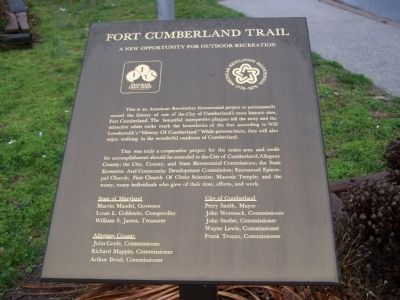
Fort Cumberland Trail
A new opportunity for outdoor recreation
— Fort Cumberland Trail —
This was truly a cooperative project for the entire area and credit for accomplishment should be extended to the City of Cumberland; Allegany County; the City, County, and State Bicentennial Commissions; the State Economic and Community Development Commission; Emmanuel Episcopal Church; First Church of Christ Scientist; Masonic Temple; and the many, many individuals who gave of their time, efforts, and work.
Topics. This historical marker is listed in this topic list: Notable Places.
Location. 39° 38.985′ N, 78° 45.89′ W. Marker is in Cumberland, Maryland, in Allegany County. Marker is at the intersection of Greene Street and Bridge Street on Greene Street. Touch for map. Marker is in this post office area: Cumberland MD 21502, United States of America. Touch for directions.
Other nearby markers. At least 8 other markers are within walking distance of this marker. Riverside Park (here, next to this marker); Where the Road Began (here, next to this marker); National Road Monument (here, next to this marker); Headquarters of George Washington (a few steps from this marker); George Washington at Will’s Creek (a few steps from this marker); Col. Thomas Cresap (a few steps from this marker); Col. Joshua Fry (within shouting distance of this marker); The Old National Pike (within shouting distance of this marker). Touch for a list and map of all markers in Cumberland.
Related markers. Click here for a list of markers that are related to this marker. This is a list of all walking tour markers in this database. 28 stops were originally erected.
Credits. This page was last revised on June 16, 2016. It was originally submitted on April 6, 2009, by Bill Pfingsten of Bel Air, Maryland. This page has been viewed 1,881 times since then and 38 times this year. Photo 1. submitted on April 6, 2009, by Bill Pfingsten of Bel Air, Maryland.
