City Center in Richmond, Virginia — The American South (Mid-Atlantic)
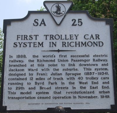
First Trolley Car System in Richmond
Erected 1988 by Department of Historic Resources. (Marker Number SA-25.)
Topics and series. This historical marker is listed in this topic list: Railroads & Streetcars. In addition, it is included in the Virginia Department of Historic Resources (DHR) series list. A significant historical month for this entry is November 1949.
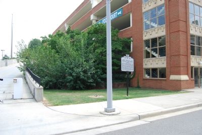
Location. 37° 32.672′ N, 77° 26.155′ W. Marker is in Richmond, Virginia. It is in City Center. Marker is on 5th Street, 0.2 miles south of Leigh Street (Virginia Route 33), on the left when traveling south. Touch for map. Marker is in this post office area: Richmond VA 23219, United States of America. Touch for directions.
Other nearby markers. At least 8 other markers are within walking distance of this marker. John Mitchell, Jr., "Fighting Editor" (about 700 feet away, measured in a direct line); Miller & Rhoads (about 800 feet away); Richmond 34 (approx. 0.2 miles away); Giles Beecher Jackson (approx. 0.2 miles away); Jackson Ward (approx. 0.2 miles away); a different marker also named The "Richmond 34" (approx. 0.2 miles away); Navy Hill (approx. 0.2 miles away); Miller’s and Eggleston Hotels (approx. 0.2 miles away). Touch for a list and map of all markers in Richmond.
Also see . . . Frank Julian Sprague, Ensign,United States Navy. (Submitted on July 29, 2007.)
Credits. This page was last revised on February 1, 2023. It was originally submitted on July 29, 2007, by Dawn Bowen of Fredericksburg, Virginia. This page has been viewed 2,440 times since then and 87 times this year. Photos: 1, 2. submitted on July 29, 2007, by Dawn Bowen of Fredericksburg, Virginia. • J. J. Prats was the editor who published this page.

