Near Bolivar in Jefferson County, West Virginia — The American South (Appalachia)
A Union Predicament
Maj. Gen. John G. Wool, USA
Telegraph message to Col. Dixon S. Miles, USA
September 7, 1862
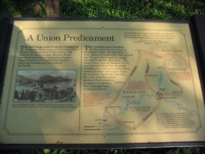
The first large-scale Federal occupation of Harpers Ferry began in February 1862. Despite the destruction of the armory and arsenal the previous year, Harpers Ferry remained important in protecting Union communication and supply lines and in deterring Confederate invasions of the North.
The Confederates invaded the North for the first time in September 1862. By September 7, Gen. Robert E. Lee's army had crossed the Potomac River and encamped outside Frederick, Maryland. The large Union force at Harpers Ferry, now located behind the invading Confederates, threatened Southern communication and supply lines. In response, Lee boldly divided his army into four parts, sending three columns to capture or destroy the Union garrison at Harpers Ferry.
Topics. This historical marker is listed in this topic list: War, US Civil. A significant historical month for this entry is February 1862.
Location. 39° 18.999′ N, 77° 45.411′ W. Marker is near Bolivar, West Virginia, in Jefferson County. Marker can be reached from Shenandoah Street, on the right when traveling north. Located near the Visitor Center in Harpers Ferry National Historic Site. Touch for map. Marker is in this post office area: Harpers Ferry WV 25425, United States of America. Touch for directions.
Other nearby markers. At least 8 other markers are within walking distance of this marker. Discover Harpers Ferry (a few steps from this marker); Confederate Victory (a few steps from this marker); Harpers Ferry National Historical Park (a few steps from this marker); The Trap Closes (within shouting distance of this marker); History in the Mountains (within shouting distance of this marker); Jackson at Harpers Ferry (approx. ¼ mile away); Home Becomes Battlefield (approx. 0.4 miles away); From Civil War to Civil Rights / Battle of Harpers Ferry (approx. 0.4 miles away). Touch for a list and map of all markers in Bolivar.
More about this marker. On the left is a drawing showing, "By early September 1862, 14,000 Federal troops occupied Harpers Ferry and vicinity, with more than half encamped on Bolivar Heights."
An operational map on the right details the movements of each part of the Confederate army. "Maj. Gen. Thomas J. 'Stonewall' Jackson's Confederate force of 14,000 traveled 51 miles in three days and occupied School House Ridge, 1/2-mile west of Bolivar Heights, on September 13."
"Maj. Gen. Lafayette McLaws' Confederate force of 8,000 captured Maryland Heights after a battle there on September 13."
"Brig. Gen. John G. Walker's Confederate force of 2,000 occupied undefended Loudoun Heights on September 13."
"After Jackson's column cornered the Federals into an inescapable position on Bolivar Heights, the trap was set. For five hours on Sunday afternoon, September 14, the Confederates fired their artillery from the captured heights. One hapless Federal wrote, '...the hissing and screeching of shot and shell discharged at us was a strange medley for a Sabbath day's worship.'
A duplicate of this marker stands on the Bolivar Heights walking trail.
Credits. This page was last revised on March 5, 2023. It was originally submitted on May 15, 2009, by Craig Swain of Leesburg, Virginia. This page has been viewed 1,115 times since then and 20 times this year. Photos: 1, 2. submitted on May 15, 2009, by Craig Swain of Leesburg, Virginia.

