Charleston in Charleston County, South Carolina — The American South (South Atlantic)
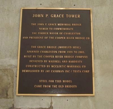
John P. Grace Tower
Named to Commemorate
The former Mayor of Charleston
And President of the Cooper River Bridge CO.
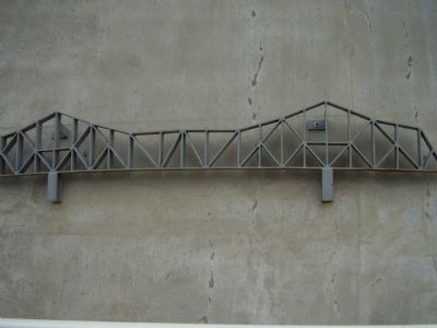
The Grace Bridge (Modeled Here)
Spanned Charleston from 1929 to 2005.
Built by the Cooper River Bridge Company
Designed by Waddell and Hardesty
Constructed by McClintic-Marshall Co.
Demolished by Jay Cashman Inc / Testa Corp.
Steel for this model
Came from the old Bridge
Topics. This historical marker is listed in this topic list: Bridges & Viaducts. A significant historical year for this entry is 1929.
Location. 32° 48.178′ N, 79° 55.052′ W. Marker is in Charleston, South Carolina, in Charleston County. Marker is on Septima Clark Expressway (U.S. 17). Touch for map. Marker is in this post office area: Charleston SC 29403, United States of America. Touch for directions.
Other nearby markers. At least 8 other markers are within walking distance of this marker. Silas N. Pearman Tower (approx. 0.3 miles away); Old Sunken Hull / BG James Estcourt Sawyer (approx. 0.7 miles away); The Cooper River Bridge / Silas N. Pearman Bridge (approx. 0.9 miles away); Riverside Beach / White's Paridise (approx. 0.9 miles away); Harry M. Hallman, Jr. (approx. 0.9 miles away); Patriots Point Naval & Maritime Museum/The Medal of Honor Museum (approx. one mile away); F-4J Phantom II (approx. one mile away); The F-4 Phantom Pilots (approx. one mile away).
Photographed By Stanley and Terrie Howard
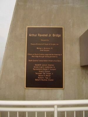
7. Arthur Ravenel Jr. Bridge Marker
Parsons Brinckerhoff Quade & Douglas, Inc.
Michael J. Abrahams, PE
Chief Designer
Citizens of South Carolina supported the financing of
this bridge through funding provided by
South Carolina Transportation Infastructure Bank
Donald D. Leonard, Chairman
Senator Hugh K. Leatherman, Sr.
Repersentative Ronald P. Townsend
Ernest L. Duncan
Tecumseh "Tee" Hooper, Jr.
Maxson K. Metcalf
Richard L. Tapp, Jr.
Debar R. Rountree, Director
Credits. This page was last revised on June 16, 2016. It was originally submitted on May 20, 2009, by Stanley and Terrie Howard of Greer, South Carolina. This page has been viewed 1,077 times since then and 32 times this year. Photos: 1, 2, 3, 4, 5, 6, 7. submitted on May 20, 2009, by Stanley and Terrie Howard of Greer, South Carolina. • Craig Swain was the editor who published this page.
