Fort Ashby in Mineral County, West Virginia — The American South (Appalachia)
American Discovery Trail
The nation's first coast-to-coast non-motorized recreation trail
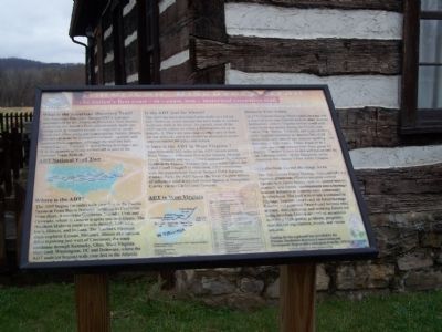
The American Discovery Trail (ADT) is a project administered by the American Discovery Trail society to develop our nation's first coast-to-coast, multi-use hiking trail. It connects people to large cities, small towns and urban areas and to mountains, forests, deserts and natural areas by incorporating local regional and national trails together. Although the trail has been mapped across America, it is still being developed and is in the process of being authorized as part of the National Trails System.
ADT National Trail Map
(map on marker)
Where is the ADT?
The ADT begins (or ends) with your feet in the Pacific Ocean at Point Reyes National Seashore in California. From there it traverses California, Nevada, Utah and Colorado, where in Denver it splits into two routes. The Northern Midwest route travels through Nebraska, Iowa, Illinois and Indiana. The Southern Midwest route explores Kansas, Missouri, Illinois and Indiana. After rejoining just west of Cincinnati, the route continues through Kentucky, Ohio, West Virginia, Maryland, Washington, DC and Delaware, where the ADT ends (or begins) with your feet in the Atlantic Ocean at Cape Henlopen State Park.
Is the ADT just for hikers?
The ADT has been developed principally as a hiking trail. However, every attempt has been made to include multi-use trails in the route. As a result, most of the ADT can be ridden on either a fat-tired bicycle or on horseback. There are some places where one or both are not allowed and trips should be planned to locate alternate routes for bikes and horses.
Where is the ADT in West Virginia?
Approximately 262 miles of the ADT stretch across West Virginia, with sixty-five miles running through Grant, Mineral and Hampshire Counties in the Potomac Headwaters Region. Another fifty plus miles follow the C&O Canal Towpath in Maryland. After connecting with the Appalachian Trail at Harpers Ferry National Historic Park, the ADT leaves the West Virginia sphere of influence until it reaches Green spring in Hampshire County via the C&O Canal Towpath
ADT in West Virginia(map and chart)
Historic Fort Ashby
In 1775(sic) Colonel George Washington directed that a chain of sixty-nine forts be built in order that the defenseless western Virginia settlers could seek safety from the enemy during the French and Indian War. Names, locations and types of these early fortified structures are known, but of all those built, only part of one remains standing - the Barracks of Fort Ashby. Today it serves as a museum and many articles have been given for display. The fort is now owned and maintained by the National Society of the Daughters of the American Revolution's Fort Ashby Chapter.
Appalachian Forest Heritage Area
The Appalachian Forest Heritage Area (AFHA) is a regional, grassroots effort to integrate central Appalachian forest history, culture, natural history, products and forestry management into a heritage tourism initiative to promote rural community development. The goal is to create a sustainable Heritage Tourism area based on forest heritage. Existing and potential forest-based historic sites, artisans, manufacturers and working forests are being developed into a network of attractions providing high quality products, programs, educational experiences, events and visitor services.
Erected by Potomac Headwaters Resource Conservation and Development Region.
Topics. This historical marker is listed in this topic list: Natural Resources.
Location. 39° 30.311′ N, 78° 45.923′ W. Marker is in Fort Ashby, West Virginia, in Mineral County. Marker is on Green St., on the left when traveling north. Marker is in front of Fort Ashby. Touch for map. Marker is in this post office area: Fort Ashby WV 26719, United States of America. Touch for directions.
Other nearby markers. At least 8 other markers are within walking distance of this marker. Fort Ashby (here, next to this marker); a different marker also named Fort Ashby (a few steps from this marker); Old Fort (a few steps from this marker); Welcome to Ashby's Fort (within shouting distance of this marker); George Washington's Orders (within shouting distance of this marker); Women at the Fort (within shouting distance of this marker); Step Back in Time (within shouting distance of this marker); The Work Continues (within shouting distance of this marker). Touch for a list and map of all markers in Fort Ashby.
Credits. This page was last revised on June 16, 2016. It was originally submitted on May 25, 2009, by Bill Pfingsten of Bel Air, Maryland. This page has been viewed 2,020 times since then and 27 times this year. Photo 1. submitted on May 25, 2009, by Bill Pfingsten of Bel Air, Maryland.
