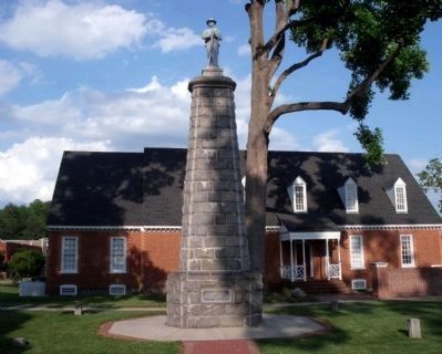
Chesterfield in Chesterfield County, Virginia — The American South (Mid-Atlantic)
Chesterfield Court House
Soldiers and Refugees
— Lee’s Retreat —
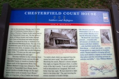
Late on the morning of Monday, April 3, 1865, part of Confederate General Robert E. Lee’s Army of Northern Virginia briefly halted here at the Chesterfield County seat. The day before, a series of Federal attacks had broken through Lee’s lines at Petersburg and ended the siege there. Lee ordered his army to withdraw from the Richmond-Petersburg fronts. The last of the Confederates came off the line that night when the moon went down. A member of the 12th Virginia Infantry on picket duty outside Petersburg later wrote, “I’ll never see the calm moon again without remembering this sad night.”
The army withdrew in four columns, three through Chesterfield County and one through Dinwiddie County, to reunite at Amelia Court House south of the Appomattox River. Gen. William Mahone’s troops were ordered to “Take the road to Chesterfield Court House, thence to old Colville to Goode’s Bridge [on the Appomattox River north of Amelia Court House].” After arriving here, a line of battle was formed “to resist a dash which was expected from the enemy but never made,” the picket recalled. Resuming the march, Mahone’s column camped that night on Captain Flournoy’s farm. A soldier wrote of the day’s march, “I am all right and not half so demoralized as I imagined. Feel much better than last night. We have resolved to fight them to the bitter end.” The next morning the column marched to Goode’s Bridge.
(sidebar)
“The Division reached Chesterfield C.H. in the fore noon of that Monday morning the third day of April. …We found the court house ground ... crowded with all manner of vehicles and women with their children - who had fled mainly from Petersburg. … A halt was made … and the troops given an opportunity to breakfast while I busied myself in bringing off and away such military wagons as had reached that place and the retreating caravan of vehicles and folks.” - Gen. William Mahone
Erected by Virginia Civil War Trails.
Topics and series. This historical marker is listed in this topic list: War, US Civil. In addition, it is included in the Virginia Civil War Trails series list. A significant historical date for this entry is April 3, 1865.
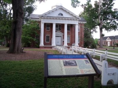
Location. 37° 22.573′ N, 77° 30.416′ W. Marker is in Chesterfield, Virginia, in Chesterfield County. Marker can be reached from the intersection of Iron Bridge Road (Virginia Route 10) and Wagners Way. This CWT panel is located on the lawn in front of the 1917 Courthouse building. Touch for map. Marker is at or near this postal address: 10021 Iron Bridge Road, Chesterfield VA 23832, United States of America. Touch for directions.
Other nearby markers. At least 8 other markers are within 3 miles of this marker, measured as the crow flies. Veterans Memorial Wall (a few steps from this marker); World War I in Chesterfield County
(within shouting distance of this marker); 1917 Courthouse (within shouting distance of this marker); Chesterfield County Courthouse (within shouting distance of this marker); Confederate Memorial (within shouting distance of this marker); Apostles of Religious Liberty (within shouting distance of this marker); Magnolia Grange (within shouting distance of this marker); George Washington Carver High School (approx. 2.6 miles away). Touch for a list and map of all markers in Chesterfield.
More about this marker. On the upper center panel is a photograph of the original courthouse with the caption, “Chesterfield County Courthouse, ca. 1750, as it appeared early in the 20th century with a late-19th-century porch. The courthouse was demolished in 1916, then reconstructed in 1977, a few yards north of the original location.” Courtesy Chesterfield County Historical Society
On the upper right is a photograph of “Gen. William Mahone” Courtesy Library of Congress
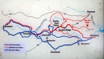
On the lower right is a map showing the route of Lee’s retreat and the Union pursuit. The caption reads, "Lee’s Army of Northern Virginia took the routes indicated in red. Lee followed the solid red route. The Union Army of the Potomac took the roads indicated in blue."
Also see . . .
1. Chesterfield County Courthouse and Courthouse Square. Wikipedia entry (Submitted on January 7, 2024, by Larry Gertner of New York, New York.)
2. Central Virginia: Richmond and Area. Civil War Traveler website entry (Submitted on June 1, 2009, by Bernard Fisher of Richmond, Virginia.)
3. Chesterfield Historical Society. Society website homepage (Submitted on June 1, 2009, by Bernard Fisher of Richmond, Virginia.)
Credits. This page was last revised on January 7, 2024. It was originally submitted on June 1, 2009, by Bernard Fisher of Richmond, Virginia. This page has been viewed 1,943 times since then and 36 times this year. Photos: 1, 2, 3, 4, 5. submitted on June 1, 2009, by Bernard Fisher of Richmond, Virginia.
