Darkesville in Berkeley County, West Virginia — The American South (Appalachia)
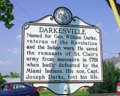
Darkesville
Topics and series. This historical marker is listed in these topic lists: Settlements & Settlers • War, US Revolutionary • Wars, US Indian. In addition, it is included in the West Virginia Archives and History series list. A significant historical year for this entry is 1791.
Location. 39° 22.167′ N, 78° 1.717′ W. Marker is in Darkesville, West Virginia, in Berkeley County. Marker is on Winchester Pike (U.S. 11) south of Hatchery Road (County Route 11/8). Touch for map. Marker is in this post office area: Inwood WV 25428, United States of America. Touch for directions.
Other nearby markers. At least 8 other markers are within 4 miles of this marker, measured as the crow flies. Col. Morgan Morgan (approx. 2.7 miles away); Christ Church (approx. 2.9 miles away); a different marker also named Christ Church (approx. 2.9 miles away); Morgan Chapel (approx. 2.9 miles away); James Johnston Pettigrew Monument (approx. 3.3 miles away); Gerrardstown Veterans Memorial (approx. 3.6 miles away); Malin-Wilson-Gray House (approx. 3.6 miles away); Mill Creek Baptist Church (approx. 3.6 miles away).
Also see . . . Biography of General William Darke. (Submitted on August 4, 2007.)
Additional keywords. Maj. Gen. Arthur St. Clair
Credits. This page was last revised on February 20, 2021. It was originally submitted on August 4, 2007, by Tom Fuchs of Greenbelt, Maryland. This page has been viewed 2,700 times since then and 42 times this year. Last updated on February 20, 2021, by Carl Gordon Moore Jr. of North East, Maryland. Photos: 1, 2. submitted on August 4, 2007, by Tom Fuchs of Greenbelt, Maryland. • Devry Becker Jones was the editor who published this page.

