Colonial Heights, Virginia — The American South (Mid-Atlantic)
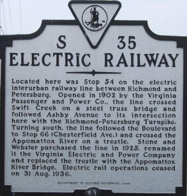
Electric Railway
Erected 2000 by Department of Historic Resources. (Marker Number S-35.)
Topics and series. This historical marker is listed in this topic list: Railroads & Streetcars. In addition, it is included in the Virginia Department of Historic Resources (DHR) series list. A significant historical year for this entry is 1902.
Location. 37° 16.748′ N, 77° 24.745′ W. Marker is in Colonial Heights, Virginia. Marker is on The Boulevard (U.S. 1) half a mile south of Harrowgate Road (Virginia Route 144), on the right when traveling south. Touch for map. Marker is in this post office area: Colonial Heights VA 23834, United States of America. Touch for directions.
Other nearby markers. At least 8 other markers are within walking distance of this marker . "Brave to Madness" (approx. ¼ mile away); Battle of Swift Creek (approx. 0.3 miles away); Union Army Checked (approx. half a mile away); Swift Creek Battlefield: A Landscape of Change (approx. half a mile away); Ellerslie (approx. ¾ mile away); a different marker also named Ellerslie (approx. ¾ mile away); Dunlop's Station (approx. 0.8 miles away); Dunlop Station (approx. 0.8 miles away). Touch for a list and map of all markers in Colonial Heights.
Additional keywords. VEPCO
Credits. This page was last revised on August 31, 2021. It was originally submitted on August 5, 2007, by Dawn Bowen of Fredericksburg, Virginia. This page has been viewed 2,819 times since then and 163 times this year. Photos: 1, 2. submitted on August 5, 2007, by Dawn Bowen of Fredericksburg, Virginia. • J. J. Prats was the editor who published this page.

