Funkstown in Washington County, Maryland — The American Northeast (Mid-Atlantic)
Building the Funkstown Bridge
— The Historic National Road - The Road That Built The Nation —
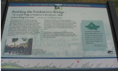
“The turnpike bridge at Funkstown is the only one...which seems to belong to a town” —Helen Ashe Hays, The Antietam and its Bridges
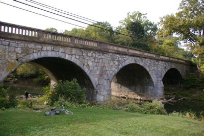
This bridge, finished in 1823, is perhaps the oldest one over Antietam Creek. Irish immigrant laborers made up the construction crew. Many worked on the road to pay off the cost of their passage from the old country, what they called “working to pay off the dead horse.” The “great brigade” of Irish leveling the roadway and breaking rocks caused one traveler to comment that they were "building a roadway good enough for any emperor to travel over…”
Workers at a local dye factory regularly taunted the immigrants. One St. Patrick’s Day, the Irish workers marched into town to avenge the insults. Local militia from Hagerstown and Funkstown arrived to keep the peace. The worst injury was “a wound by the kick of a horse.”
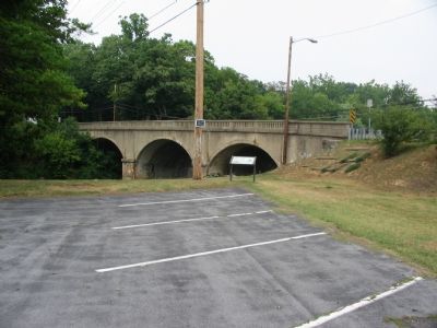
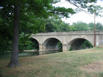
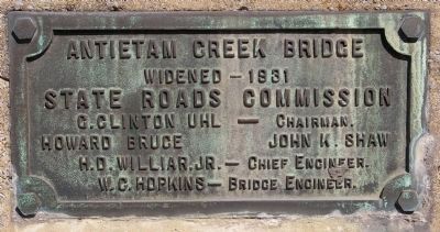
The Bridge was widened in 1931 with the addition of a concrete facade on the side that faces you. The original stone facing remains on the opposite side.
“The trolley from Hagerstown brings holiday-makers who row on the creek and make picnics along its banks....In summer the water is alive with craft...and there is a continual hum of laughter and cheerful voices.” —Helen Ashe Hays, The Antietam and its Bridges.
Topics and series. This historical marker is listed in these topic lists: Bridges & Viaducts • Roads & Vehicles. In addition, it is included in the The Historic National Road series list. A significant historical year for this entry is 1823.
Location. 39° 36.724′ N, 77° 42.612′ W. Marker is in Funkstown, Maryland, in Washington County. Marker is on North Westside Avenue / Old National Road (Alternate U.S. 40), on the left. Located in the American Legion Post 211 parking lot, behind the hall. Touch for map. Marker is at or near this postal address: 12 North Westside Avenue, Funkstown MD 21734, United States of America. Touch for directions.
Other nearby markers. At least 8 other markers are within walking distance of this marker. Veterans Memorial (about 400 feet away, measured in a direct line); M3A1 Light Tank (about 400 feet away); Funkstown Bridge No. 2 (about 700 feet away); Civil War Hospital Site (approx. 0.2 miles away); Baltimore Street (approx. ¼ mile away); Keller Home (approx. ¼ mile away); Gen. Robert E. Lee (approx. 0.3 miles away); This Plot is Dedicated to Public Use (approx. 0.3 miles away). Touch for a list and map of all markers in Funkstown.
More about this marker. The marker has a picture of the bridge as it looked in the early 20th Century, “Electric powered trolleys running between Funkstown and Hagerstown began crossing the bridge in 1901. The last trolley ran in 1939.” A silhouette of a couple in a rowboat highlights the sidebar quote. The background of the marker is “National Road at Fairview Inn” from the Enoch Pratt Library Cator Collection.
Also see . . . Journey Through Maryland History: Washington County Bridges. Preservation Maryland website entry (Submitted on February 28, 2022, by Larry Gertner of New York, New York.)
Photographed By Christopher Busta-Peck
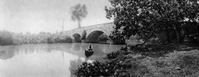
4. Funkstown Turnpike Bridge, circa 1910
Photograph by John C. Artz. From The Antietam and Its Bridges: The Annals of an Historic Stream by Helen Ashe Hays. New York: G. P. Putman's Sons, 1910. The photograph is looking upstream (north), at the side of the bridge presently covered by concrete.
Credits. This page was last revised on March 24, 2024. It was originally submitted on August 6, 2007, by Craig Swain of Leesburg, Virginia. This page has been viewed 2,368 times since then and 28 times this year. Photos: 1, 2, 3. submitted on August 6, 2007, by Craig Swain of Leesburg, Virginia. 4. submitted on February 19, 2008, by Christopher Busta-Peck of Shaker Heights, Ohio. 5. submitted on March 24, 2008, by Christopher Busta-Peck of Shaker Heights, Ohio. 6. submitted on January 17, 2008, by Christopher Busta-Peck of Shaker Heights, Ohio. • J. J. Prats was the editor who published this page.
