Near Lutherville-Timonium in Baltimore County, Maryland — The American Northeast (Mid-Atlantic)
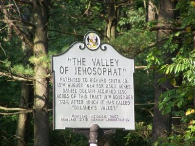
“The Valley of Jehosophat”
Erected by Maryland Historical Trust, Maryland State Highway Administration.
Topics and series. This historical marker is listed in these topic lists: Colonial Era • Settlements & Settlers. In addition, it is included in the Maryland Historical Trust series list. A significant historical date for this entry is November 19, 1724.
Location. 39° 27.123′ N, 76° 35.553′ W. Marker is near Lutherville-Timonium, Maryland, in Baltimore County. Marker is on Dulaney Valley Road, 0.2 miles north of Surrey Road, on the right. Touch for map. Marker is at or near this postal address: 2240 Dulaney Valley Rd, Lutherville Timonium MD 21093, United States of America. Touch for directions.
Other nearby markers. At least 8 other markers are within 2 miles of this marker, measured as the crow flies. Northampton Furnace (approx. ¾ mile away); The American Gold Star Mothers (approx. 1.6 miles away); Ensign C. Markland Kelly, Jr. Memorial (approx. 1.6 miles away); “The Eagle’s Nest” (approx. 1.6 miles away); General James P. S. Devereux Memorial (approx. 1.6 miles away); World War II and Korean War Memorial (approx. 1.6 miles away); The Field of Honor (approx. 1.6 miles away); Memorial to Marylanders-Liberation of Kuwait (approx. 1.6 miles away).
More about this marker. This marker replaced another one with identical text, erected by the Maryland State Roads Commission, in 1937.
Credits. This page was last revised on April 20, 2021. It was originally submitted on August 13, 2007, by Bill Pfingsten of Bel Air, Maryland. This page has been viewed 4,108 times since then and 81 times this year. Photos: 1. submitted on August 15, 2007, by Bill Pfingsten of Bel Air, Maryland. 2. submitted on April 11, 2021, by Allen C. Browne of Silver Spring, Maryland. • J. J. Prats was the editor who published this page.

