Waynesville in Pulaski County, Missouri — The American Midwest (Upper Plains)
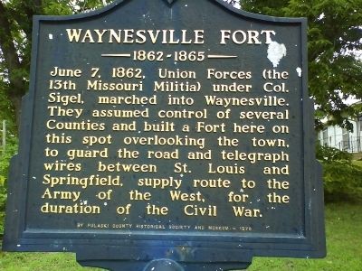
Waynesville Fort
1862-1865
Erected 1970 by Pulaski County Historical Society and Museum.
Topics. This historical marker is listed in this topic list: War, US Civil. A significant historical date for this entry is June 7, 1862.
Location. 37° 49.616′ N, 92° 12.038′ W. Marker is in Waynesville, Missouri, in Pulaski County. Marker is at the intersection of Fort Street and DeWitt Street, on the right when traveling east on Fort Street. Touch for map. Marker is in this post office area: Waynesville MO 65583, United States of America. Touch for directions.
Other nearby markers. At least 8 other markers are within walking distance of this marker. Pulaski County (about 700 feet away, measured in a direct line); Rigsby House and Standard Oil Station (about 800 feet away); Discover a Hidden History (about 800 feet away); Old Stage Coach Stop (approx. 0.2 miles away); A Trail of Tragedy (approx. 0.2 miles away); A Resting Place for the Weary (approx. 0.2 miles away); What is the Trail of Tears? (approx. 0.2 miles away); Talbot House (approx. 0.2 miles away). Touch for a list and map of all markers in Waynesville.
Credits. This page was last revised on June 16, 2016. It was originally submitted on August 1, 2009, by Snoop Dorky Dork of Waynesville, Missouri. This page has been viewed 1,789 times since then and 45 times this year. Photos: 1, 2. submitted on August 1, 2009, by Snoop Dorky Dork of Waynesville, Missouri. • Craig Swain was the editor who published this page.

