Truckee in Nevada County, California — The American West (Pacific Coastal)
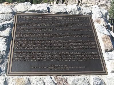
Stephens – Townsend – Murphy Party of 1844
First Pioneer Wagons Over The Sierra Nevada
The Murphy, Townsend, Miller, and Hitchcock families formed the main groups of the party. Caleb Greenwood was the hired guide, and Elisha Stephens was elected Captain of the wagon train.
After following the Oregon Trail to Fort Hall, Idaho, they turned away from the well-worn path and headed west into the unfamiliar Nevada desert. A Paiute Indian Chief showed them how to reach a river flowing from the Sierra Nevada, which they named “Truckee” in his honor.
Overcoming severe conditions, they followed the Truckee River to the base of the Sierra. Six members, on horseback, continued to follow the Truckee River and eventually arrived safely at Sutter’s New Helvetia on December 10, 1844. Six of the wagons were left in the charge of two men, and young Moses Schallenberger, near Truckee Lake (present Donner Lake). Near this spot, with two feet of snow on the ground, they worked the remaining five wagons across the summit of the mighty Sierra Nevada on November 25, 1844.
Deepening snow forced them to camp near Big Bend, on the South Yuba River. Leaving the wagons with two men and the women and children, the remaining 17 men continued on to New Helvetia to seek help. Somehow, John Sutter persuaded the men to enlist in his forces taking part in a Mexican Civil War. Eventually the families were reunited, and all members (including two babies born on the way) arrived safely at Sutter’s Fort in early March 1845.
Erected 1994 by Nevada County Historical Landmarks Commission, September 24, 1994.
Topics and series. This historical marker is listed in these topic lists: Native Americans • Roads & Vehicles • Settlements & Settlers. In addition, it is included in the California Trail, and the Truckee Trail series lists. A significant historical date for this entry is March 8, 1845.
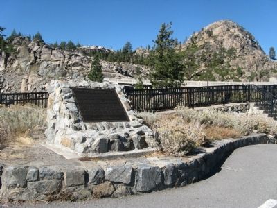
Location. 39° 19.126′ N, 120° 19.131′ W. Marker is in Truckee, California, in Nevada County. Marker can be reached from Donner Pass Road (Old Highway 40). Marker is located at the lookout parking area near the walkway to the bridge. Touch for map. Marker is at or near this postal address: 19326 Donner Pass Road, Truckee CA 96161, United States of America. Touch for directions.
Other nearby markers. At least 8 other markers are within walking distance of this marker. Transcontinental Railroad (within shouting distance of this marker); McGlashan Point (within shouting distance of this marker); Donner Pass (within shouting distance of this marker); Rainbow Bridge (within shouting distance of this marker); Donner Summit Overlook (within shouting distance of this marker); Donner Summit Bridge (within shouting distance of this marker); Petroglyphs (about 600 feet away, measured in a direct line); China Wall (about 600 feet away). Touch for a list and map of all markers in Truckee.
Regarding Stephens – Townsend – Murphy Party of 1844. See the Nearby Marker "Schallenberger Cabin Site" for additional information.
Related markers. Click here for a list of markers that are related to this marker. To better understand the relationship, study each marker in the order shown.
Credits. This page was last revised on October 22, 2020. It was originally submitted on October 23, 2009, by Syd Whittle of Mesa, Arizona. This page has been viewed 2,685 times since then and 43 times this year. Photos: 1, 2. submitted on October 23, 2009, by Syd Whittle of Mesa, Arizona.

