Leesburg in Loudoun County, Virginia — The American South (Mid-Atlantic)
Battle of Balls Bluff
October 21, 1861
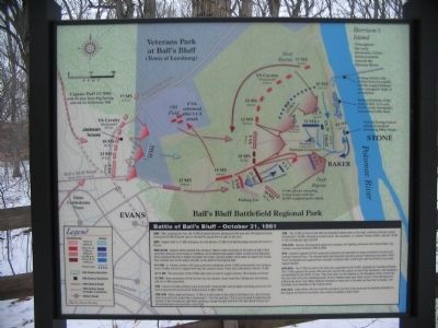
6 AM - After crossing the river, the 15 MA (Colonel Devens) advanced to the area near the Jackson house, leaving the 20 MA (Colonel Lee) on the bluff to guard the exit path to the river.
8 AM - Captain Duff's (17 MS) Company ran into Devens (15 MA) and fighting began around the Jackson House.
9A M - 10 AM - General Stone ordered Col. (Senator) Baker to take command of all forces on Ball's Bluff and either advance more troops or withdraw, as he deemed appropriate. Baker arrived on the Maryland shore opposite Harrison's Island and spent four hours trying to gather more boats to support his forces, then crossed over to the island, and then to the bluff on the Virginia Side.
9-11 AM - Lt. Colonel Jenifer's VA Cavalry and two companies of the 18 MS (and possibly one company of the 13 MS) arrived to support Duff near the Jackson house. These units skirmished with the 15 MA.
10-11 AM - The remainder of the 15 MA (350 men) arrived to support Devens. Skirmishing continued.
12-1 PM - Nine companies of 8 VA arrived near the Jackson house from Burnt Bridge and skirmishing with the 15 MA intensified.
2 PM - Devens (15 MA) withdrew back to the bluff. He found that Colonel Baker had finally arrived on the field to assume full command of Federal forces on Ball's Bluff.
2 PM - 3 PM - Baker deployed Devens' 15 MA at right angle to the right of the Federal line, thus forming what, from the bluff, looked like a backwards "L." He then sent the 1 CA (2 cos) forward to determine the location of the Confederate right flank, sparking a sharp fire fight with the 8 VA. Both the 8 VA and the 1 CA retreated and reformed after a brief fight.
3 PM - The 18 MS arrived on the field and attacked Federal units on the bluff, suffering a bloody repulse. Colonel Burt (18 MS) received a mortal wound. His successor, Lt. Colonel Thomas Griffin, split the 18 MS to the Confederate right and left.
3 PM-5 PM - General, disorganized squad and company size fighting continued until Colonel Baker was mortally wounded between 4 PM & 5 PM.
5 PM - Colonel Cogswell (42 NY) assumed command and attempted to forge a breakout from the bluff toward Edwards Ferry. The attempt failed and Cogswell ordered a general withdrawal from Ball's Bluff. The 8 VA attacked and captured two mountain howitzers after a brief fight with the 20 MA (2 co) under Captain Bartlett.
5 PM-6 PM - The 17 MS arrived on the field and, supported by the 18 MS, attacked the retreating Federals. The 17 MS captured the James rifle (and also claimed the capture of one of the howitzers), and repulsed a counterattack by the 42 NY (2 cos). They fired down on the Federals on the floodplain, those swimming the river, and in the four retreating boats. All four Federal boats were either sunk or were damaged and drifted away down river. Many Federals drowned or were shot in the water as they tried to escape, and hundreds were stranded on the Virginia shore.
After Dark - Elijah White (VA Cav) with 50 volunteers from the 8 VA convinced the Federals stranded on the Virginia shoreline to surrender, thus ending the Battle of Ball's Bluff.
Topics. This historical marker is listed in this topic list: War, US Civil.
Location. 39° 7.826′ N, 77° 31.843′ W. Marker is in Leesburg, Virginia, in Loudoun County. Marker is on Ballís Bluff Road, on the right when traveling east. Located inside Ballís Bluff Regional Park, just off the parking lot. Touch for map. Marker is in this post office area: Leesburg VA 20176, United States of America. Touch for directions.
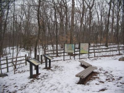
Other nearby markers. At least 8 other markers are within walking distance of this marker. Additional Area Civil War Sites (here, next to this marker); Aftermath of Ballís Bluff (here, next to this marker); The Battle of Ball's Bluff in Perspective (here, next to this marker); A Divided America, A Divided Loudoun County (here, next to this marker); The Battle at Ballís Bluff (within shouting distance of this marker); Battle of Ball's Bluff - October 21, 1861 (about 300 feet away, measured in a direct line); a different marker also named The Battle of Ball's Bluff (about 300 feet away); 8th Virginia Volunteer Infantry Regiment (about 400 feet away). Touch for a list and map of all markers in Leesburg.
More about this marker. The background of the marker is a map of the battle as described in the text.
Credits. This page was last revised on March 6, 2021. It was originally submitted on February 16, 2010, by Craig Swain of Leesburg, Virginia. This page has been viewed 1,594 times since then and 34 times this year. Photos: 1, 2. submitted on February 16, 2010, by Craig Swain of Leesburg, Virginia.

