Near Andrews in Williamsburg County, South Carolina — The American South (South Atlantic)
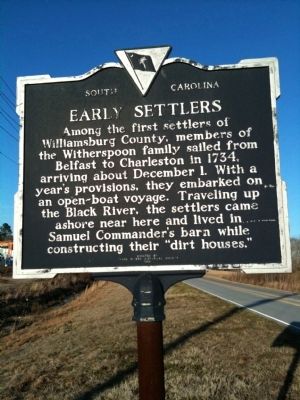
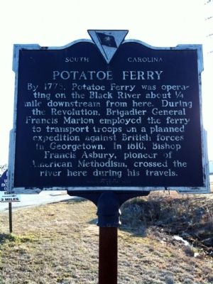
Early Settlers / Potatoe Ferry
Erected 1989 by Three Rivers Historical Society. (Marker Number 45-9.)
Topics and series. This historical marker is listed in these topic lists: Colonial Era • Settlements & Settlers • Waterways & Vessels. In addition, it is included in the Francis Asbury, Traveling Methodist Preacher, and the South Carolina, Williamsburg County, Three Rivers Historical Society series lists. A significant historical date for this entry is December 1, 1963.
Location. 33° 29.685′ N, 79° 32.447′ W. Marker is near Andrews, South Carolina, in Williamsburg County. Marker is at the intersection of Thurgood Marshall Highway (State Highway 527) and County Line Road (State Highway 41) on Thurgood Marshall Highway. Touch for map. Marker is in this post office area: Andrews SC 29510, United States of America. Touch for directions.
Other nearby markers. At least 10 other markers are within 11 miles of this marker, measured as the crow flies. Georgetown County National Guard Memorial (approx. 3.3 miles away); Mt. Zion A.M.E. Church (approx. 4½ miles away); Oak Grove Methodist Church (approx. 8.6 miles away); Prince George Winyah Parish / Prince Frederick’s Parish (approx. 9.1 miles away); Black Mingo Presbyterian Meeting House (approx. 9.4 miles away); Skirmish at Sampit Bridge (approx. 10.2 miles away); Sampit Methodist Church (approx. 10.2 miles away); Black Mingo – Willtown / Black Mingo Baptist Church (approx. 10.4 miles away); Black Mingo Creek: (approx. 10.8 miles away); Skirmish At Black Mingo Creek (approx. 10.8 miles away). Touch for a list and map of all markers in Andrews.
Credits. This page was last revised on June 16, 2016. It was originally submitted on February 24, 2010, by David Bullard of Seneca, South Carolina. This page has been viewed 1,821 times since then and 51 times this year. Last updated on March 2, 2010, by Michael Sean Nix of Spartanburg, South Carolina. Photos: 1, 2. submitted on February 24, 2010, by David Bullard of Seneca, South Carolina. • Kevin W. was the editor who published this page.

