Bartlett in Bell County, Texas — The American South (West South Central)
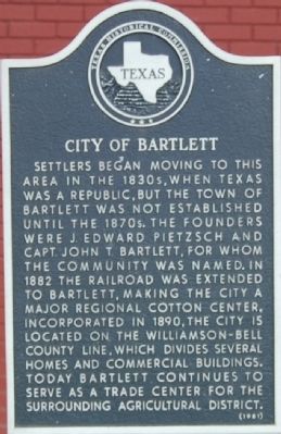
City of Bartlett
Erected 1981 by Texas Historical Commission. (Marker Number 315.)
Topics. This historical marker is listed in this topic list: Settlements & Settlers. A significant historical year for this entry is 1882.
Location. 30° 47.755′ N, 97° 25.759′ W. Marker is in Bartlett, Texas, in Bell County. Marker is on W. Clark St., on the right when traveling west. Touch for map. Marker is at or near this postal address: 140 W Clark St, Bartlett TX 76511, United States of America. Touch for directions.
Other nearby markers. At least 8 other markers are within walking distance of this marker. Woman's Wednesday Club (a few steps from this marker); First Baptist Church of Bartlett (about 500 feet away, measured in a direct line); Bartlett Grammar School (approx. 0.2 miles away); First Presbyterian Church of Bartlett (approx. 0.2 miles away); First National Bank of Bartlett (approx. ¼ mile away); Site of Booker T. Washington School (approx. 0.3 miles away); First United Methodist Church of Bartlett (approx. 0.4 miles away); Mount Arie (Mount Ararat) Missionary Baptist Church (approx. 0.4 miles away). Touch for a list and map of all markers in Bartlett.
Credits. This page was last revised on November 2, 2020. It was originally submitted on March 23, 2010, by Keith Peterson of Cedar Park, Texas. This page has been viewed 1,072 times since then and 32 times this year. Photo 1. submitted on March 23, 2010, by Keith Peterson of Cedar Park, Texas. • Bill Pfingsten was the editor who published this page.
Editor’s want-list for this marker. A photo of the marker and the surrounding area in context. • Can you help?
