Salado in Bell County, Texas — The American South (West South Central)
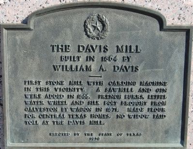
The Davis Mill
William A. Davis
Erected 1936 by the State of Texas. (Marker Number 1179.)
Topics and series. This historical marker is listed in this topic list: Industry & Commerce. In addition, it is included in the Texas 1936 Centennial Markers and Monuments series list. A significant historical year for this entry is 1864.
Location. 30° 56.676′ N, 97° 32.224′ W. Marker is in Salado, Texas, in Bell County. Marker is at the intersection of South Main Street and Pace Park Road, on the right when traveling north on South Main Street. North of the Salado Creek bridge. Touch for map. Marker is at or near this postal address: 210 Main St, Salado TX 76571, United States of America. Touch for directions.
Other nearby markers. At least 8 other markers are within walking distance of this marker. First Baptist Church of Salado (within shouting distance of this marker); Kate and Zachary Taylor (about 300 feet away, measured in a direct line); Louisa Adeline (Addie) Barton (about 300 feet away); Church Bell (about 400 feet away); Home of Orville Thomas Tyler (about 400 feet away); Salado Creek (about 500 feet away); Salado (about 500 feet away); Main Street Bridges (about 500 feet away). Touch for a list and map of all markers in Salado.
Credits. This page was last revised on June 19, 2018. It was originally submitted on March 28, 2010, by Keith Peterson of Cedar Park, Texas. This page has been viewed 1,107 times since then and 16 times this year. Photos: 1. submitted on March 28, 2010, by Keith Peterson of Cedar Park, Texas. 2. submitted on June 18, 2018, by Larry D. Moore of Del Valle, Texas. • Kevin W. was the editor who published this page.

