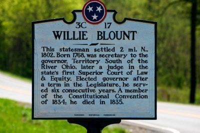
Near Clarksville in Montgomery County, Tennessee — The American South (East South Central)
Willie Blount
Erected by Tennessee Historical Commission. (Marker Number 3C 17.)
Topics and series. This historical marker is listed in this topic list: Government & Politics. In addition, it is included in the Tennessee Historical Commission series list. A significant historical year for this entry is 1802.
Location. 36° 27.891′ N, 87° 9.14′ W. Marker is near Clarksville, Tennessee, in Montgomery County. Marker is at the intersection of U.S. 41A and Mt. Carmel Road, on the right when traveling north on U.S. 41A. Touch for map. Marker is in this post office area: Clarksville TN 37040, United States of America. Touch for directions.
Other nearby markers. At least 8 other markers are within 7 miles of this marker, measured as the crow flies. Pat Head Summitt (approx. 4.8 miles away); Port Royal (approx. 5.2 miles away); Renfroe's Station (approx. 5.4 miles away); The Town of Port Royal (approx. 6.2 miles away); 1859 Masonic Lodge & General Store (approx. 6.2 miles away); Stores of Port Royal (approx. 6.2 miles away); Clifton Methodist Church (approx. 7 miles away); Clifton Forebears are Buried in Old Church Cemetery to Southeast (approx. 7 miles away).
Credits. This page was last revised on September 22, 2020. It was originally submitted on April 11, 2010. This page has been viewed 1,033 times since then and 16 times this year. Last updated on April 18, 2010. Photos: 1, 2. submitted on April 11, 2010, by Paul Landry of Nashville, Tennessee. • Kevin W. was the editor who published this page.

