Galena in Kent County, Maryland — The American Northeast (Mid-Atlantic)
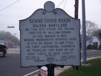
Downs’ Cross Roads
Galena, Maryland
Erected 1932 by Kent Lodge instituted 1851, Massey Lodge 157 instituted 1914, Independent Order of Odd Fellows.
Topics and series. This historical marker is listed in these topic lists: Colonial Era • Industry & Commerce • Patriots & Patriotism • Roads & Vehicles. In addition, it is included in the Former U.S. Presidents: #01 George Washington, and the George Washington Slept Here series lists. A significant historical year for this entry is 1763.
Location. 39° 20.44′ N, 75° 52.73′ W. Marker is in Galena, Maryland, in Kent County. Marker is at the intersection of South Main Street (Maryland Route 313/290) and W. Cross Street (Maryland Route 213), on the left when traveling north on South Main Street. Touch for map. Marker is in this post office area: Galena MD 21635, United States of America. Touch for directions.
Other nearby markers. At least 8 other markers are within 5 miles of this marker, measured as the crow flies. Mistress Kitty Knight (approx. 1.4 miles away); Georgetown, Maryland (approx. 1.4 miles away); Daring to Resist (approx. 1˝ miles away); A Heavy Price (approx. 1˝ miles away); Sassafras River (approx. 1.7 miles away); Fort Duffy (approx. 1.8 miles away); Greenfield (approx. 3.4 miles away); Mount Harmon Plantation at World's End (approx. 4.1 miles away).
More about this marker. Route 313 reaches N end in Galena. Use route 213 to continue N toward Cecil County.
Route 213 runs on W. Cross Street and N. Main Street.
Route 290 runs on S. Main Street and E. Cross Street.
Credits. This page was last revised on August 31, 2020. It was originally submitted on October 18, 2007, by Bill Pfingsten of Bel Air, Maryland. This page has been viewed 1,831 times since then and 48 times this year. Last updated on August 30, 2020, by Carl Gordon Moore Jr. of North East, Maryland. Photo 1. submitted on October 18, 2007, by Bill Pfingsten of Bel Air, Maryland.
