Bloomery in Hampshire County, West Virginia — The American South (Appalachia)
Fight at Bloomery Gap
A Futile Affair
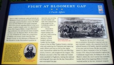
Early in 1862, Confederate raids and attacks put Hampshire County and much of the surrounding area under nominal Southern control. The Baltimore and Ohio Railroad and nearby telegraph wires were severed, impeding Federal troop movements. A militia brigade under Col. Jacob Sencendiver, 67th Virginia Militia, occupied Bloomery Gap to threaten the railroad and Union-occupied territory near the Potomac River. To drive them out, Gen. Frederick W. Lander led a mixed force of infantry and cavalry south from Paw Paw, Morgan County, on the afternoon of February 13. He intended to strike Sencendiverís position at dawn the next morning, but bad weather and high water delayed him long enough for the Confederate pickets to give warning.
Sencendiver hastily ordered the wagons packed and sent east, while posting the 31st Virginia Infantry to block Landerís advance. Lander led the charge of part of the 1st West Virginia Cavalry, overrunning and scattering the Virginians and capturing many officers and men as well as the wagon train. Sencendiver rallied the 67th and 78th Regiments, however, and recaptured the wagons. The Federals returned to Paw Paw while the Confederates marched to Pughtown, leaving the railroad and telegraph lines open for the day. Sencendiver soon reoccupied the gap.
Except for the loss of 67 officers and men as prisoners, Sencendiver reported only two men wounded. Lander, who requested that he be relieved because of ill health, reported casualties of two men and six horses. He also court-martialed Col. Henry Anisansel of the 1st Virginia Cavalry (US), whom he had ordered to capture the Confederate wagon train, for failing to do so. On March 2, before the court martial was concluded, Lander died of the lingering effects of wounds received earlier in the war. Anisansel resigned.
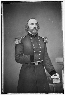
(Sidebar): Gen. Frederick W. Lander (1821-1862), a native of Salem, Massachusetts, was a civil engineer who surveyed the Lander Road from the Wyoming Territory to the Oregon Territory. The road was completed in 1859. When the war began, he served first as an aide to Gen. George B. McClellan, then obtained a generalís commission and proved himself a capable leader. He was also an accomplished poet. Lander was severely wounded on October 27, 1861, at the Battle of Ballís Bluff in Virginia but continued to serve until he died.
Erected 2010 by West Virginia Civil War Trails.
Topics and series. This historical marker is listed in this topic list: War, US Civil. In addition, it is included in the West Virginia Civil War Trails series list. A significant historical date for this entry is February 13, 1800.
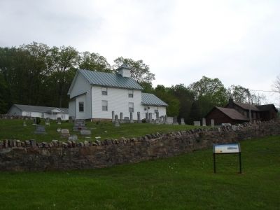
Location. 39° 23.24′ N, 78° 22.448′ W. Marker is in Bloomery, West Virginia, in Hampshire County. Marker is on Bloomery Pike (West Virginia Route 127), on the right when traveling west. The marker is located at on the grounds of the Bloomery Presbyterian Church. Touch for map. Marker is in this post office area: Bloomery WV 26817, United States of America. Touch for directions.
Other nearby markers. At least 8 other markers are within 7 miles of this marker, measured as the crow flies. Bloomery Iron Furnace / Bloomery Gap Skirmish (approx. 2.1 miles away); Hampshire County / Virginia (approx. 2.1 miles away); ďCaudyís CastleĒ (approx. 2Ĺ miles away); West Virginia (Morgan County) / Virginia (approx. 5.4 miles away); Pinoak Fountain (approx. 5Ĺ miles away); Overlook at Cacapon State Park (approx. 6 miles away); Cacapon Mountain Overlook (approx. 6 miles away); Ridge Fish Hatchery (approx. 6.2 miles away).
More about this marker. On the upper right of the marker is a sketch captioned, Federal cavalry charge, Harper's Weekly, Feb. 8, 1862. The sidebar on the lower left features a portrait captioned, Gen. Frederick W. Lander Courtesy Rick Wolfe.
Also see . . . Bloomery Gap - Official Reports of Gen. Lander and Col. Sencendiver. Romney Campaign Simulation website entry (Submitted on May 8, 2010.)
Credits. This page was last revised on January 31, 2022. It was originally submitted on May 8, 2010. This page has been viewed 3,016 times since then and 80 times this year. Photos: 1, 2, 3. submitted on May 8, 2010. • Craig Swain was the editor who published this page.


