Carmichael in Queen Anne's County, Maryland — The American Northeast (Mid-Atlantic)
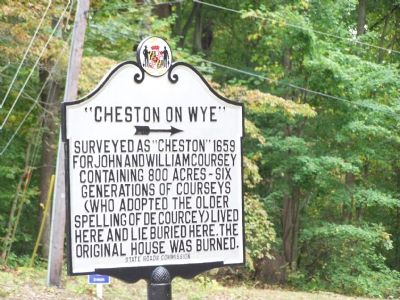
“Cheston on Wye”
→
Erected 1939 by State Roads Commission.
Topics. This historical marker is listed in these topic lists: Cemeteries & Burial Sites • Colonial Era • Settlements & Settlers. A significant historical year for this entry is 1659.
Location. 38° 55.934′ N, 76° 7.844′ W. Marker is in Carmichael, Maryland, in Queen Anne's County. Marker is at the intersection of Carmichael Road and Cheston Road, on the right when traveling south on Carmichael Road. Touch for map. Marker is in this post office area: Queenstown MD 21658, United States of America. Touch for directions.
Other nearby markers. At least 8 other markers are within 3 miles of this marker, measured as the crow flies. Site of Stagwell (approx. 0.3 miles away); “Wye Plantation” (approx. 1.1 miles away); Wye Island (approx. 1.2 miles away); Governor Robert Wright (approx. 1.8 miles away); Governor William Grason (approx. 2½ miles away); Historic Points (approx. 2.6 miles away); A Glimpse Inside a Giant (approx. 2.7 miles away); “Bloomingdale” (approx. 2.7 miles away). Touch for a list and map of all markers in Carmichael.
Also see . . . DeCoursey Genealogy. Genealogical background on the DeCourseys. (Submitted on November 2, 2007, by Kevin W. of Stafford, Virginia.)
Credits. This page was last revised on November 22, 2019. It was originally submitted on October 24, 2007, by Bill Pfingsten of Bel Air, Maryland. This page has been viewed 2,561 times since then and 47 times this year. Photo 1. submitted on October 24, 2007, by Bill Pfingsten of Bel Air, Maryland. • Kevin W. was the editor who published this page.
Editor’s want-list for this marker. Old photographs of the original house • Can you help?
