Montpelier Station in Orange County, Virginia — The American South (Mid-Atlantic)
Confederate Camp & Freedman's Farm Trail
With the Confederate surrender in 1865, slaves were emancipated across Virginia and the American South and were officially known as freedmen. Montpelier's Gilmore Farm was the homestead of one emancipated family. The restored farm preserves the African-American experience of emerging from slavery and becoming citizens of the United States.
The Confederate Camp and Freedman's Farm interpretive trail passes through a portion of the Confederate winter camp and leads to the Gilmore Farm, a farm settled by a freedman who was a slave of James Madison's. A direct return path is provided, parallel to Route 20. The round-trip distance is just under one mile, through generally level woodlands. An interpretive sign is located at each star on the map.
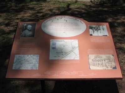
Confederate General Samuel McGowan
One of three brigades camped at Montpelier was McGowan's South Carolinians. During the winter months, these troops patrolled the Rapidan River and "planked" the road leading to the town of Orange (modern-day Route 20), cutting and sawing trees into heavy boards and laying them over the road's rutted surface. The road improvements allowed the troops to deploy quickly when Union forces were detected in the early morning hours of May 4, 1864, at Germanna Ford, about 30 miles east of Montpelier. Later that morning, General McGowan's 1,500-man brigade was on the march and within 24 hours was engaged in the Battle of the Wilderness. This battle alone claimed one third of McGowan's forces.
1864 Meade Map of Orange County showing Confederate General Robert E. Lee's encampments
Following the defeat at Gettysburg, Lee retreated to Orange County and positioned his army along a 30-mile front behind the Rapidan River. The soldiers built and manned observation posts on high spots, such as Clarke Mountain, to keep watch over Union troops on the north side of the Rapidan. Following the Union army's unsuccessful attempts to move south, culminating with the Mine Run campaign in November 1863, both sides went into winter quarters and waited until spring to resume major operations.
1920s photograph of George and Polly Gilmores grandsons and daughter or daughter-in-law
Following the Civil War, thousands of former slaves in Orange County made the transition to freedom. Most emancipated slaves stayed in the area and sought work wherever it was available. For many this meant working on the same plantations where they once labored as slaves - but now earning wages. Owning land was a universal goal among freedmen, and Montpelier's Gilmore Farm is the homestead where one emancipated African-American family realized this goal.
1863 Sketch of Montpelier Mansion made by visiting soldier
Throughout the Civil War, Montpelier was owned by Frank and Thomas Carson, two Irish brothers with banking interests in Baltimore. The Montpelier house was not occupied by Confederate officers as a headquarters, but was a landmark that drew many visiting soldiers. Frank Carson hosted a ball given by General J.E.B. Stuart at Montpelier, and he allowed the house to serve as a venue for a court martial case where seven Confederate soldiers were condemned to death for desertion.
Topics and series. This historical marker is listed in these topic lists: African Americans • War, US Civil. In addition, it is included in the Former U.S. Presidents: #04 James Madison series list. A significant historical month for this entry is May 1854.
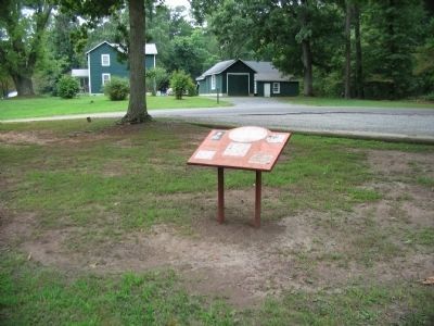
Location. This marker has been replaced by another marker nearby. 38° 13.747′ N, 78° 10.598′ W. Marker is in Montpelier Station, Virginia, in Orange County. Marker is at the intersection of Constitution Highway (State Highway 20) and County Route 693, on the right when traveling west on Constitution Highway. Located in a parking lot at the start of the trail mentioned on the marker. Touch for map. Marker is in this post office area: Montpelier Station VA 22957, United States of America. Touch for directions.
Other nearby markers. At least 8 other markers are within walking distance of this location. Civil War & Gilmore Farm Trail (a few steps from this marker); Madison-Barbour Rural Historic District (within shouting distance of this marker); Montpelier Train Station (within shouting distance of this marker); Montpelier Flag Stop (within shouting distance of this marker); Civil War Encampment (approx. ¼ mile away); Gilmore Family Cemetery (approx. ¼ mile away); Dolley Madison (approx. ¼ mile away); Gilmore Farm (approx. 0.3 miles away). Touch for a list and map of all markers in Montpelier Station.
More about this marker. This marker was replaced by a new one named Civil War & Gilmore Farm Trail (see nearby markers).
The marker displays a portrait of Gen. McGowan, a section of the Meade Map, a photo of the Gilmore family descendants, a wartime sketch of Montpelier, and a trail map of the site. At the bottom is a time-line spanning from 1732 when the Madison Family moved to Montpelier; through 1844 when Dolley Madison sold Montpelier; the start of the Civil War in 1861; to 1863 when Montpelier lands were occupied by Lee's forces; through 1865 when the 13th Amendment abolished slavery; to 1873 when the Gilmore cabin was built; ending at 1905 when George Gilmore died.
Also see . . .
1. Civil War Encampment. Page from the Montpelier web site detailing the camps and the trail. (Submitted on June 9, 2010, by Craig Swain of Leesburg, Virginia.)
2. The Gilmore Farm. Page from the Montpelier website detailing the freedman's farm. (Submitted on June 9, 2010, by Craig Swain of Leesburg, Virginia.)
Credits. This page was last revised on November 16, 2022. It was originally submitted on June 9, 2010, by Craig Swain of Leesburg, Virginia. This page has been viewed 1,812 times since then and 75 times this year. Photos: 1, 2. submitted on June 9, 2010, by Craig Swain of Leesburg, Virginia.

