Ellicott City in Howard County, Maryland — The American Northeast (Mid-Atlantic)
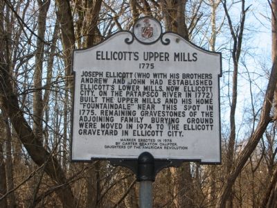
Ellicott’s Upper Mills
1775
Erected 1976 by Carter Braxton Chapter of the Daughters of the American Revolution.
Topics and series. This historical marker is listed in these topic lists: Cemeteries & Burial Sites • Colonial Era • Industry & Commerce • Settlements & Settlers. In addition, it is included in the Daughters of the American Revolution series list. A significant historical year for this entry is 1775.
Location. 39° 18.62′ N, 76° 47.627′ W. Marker is in Ellicott City, Maryland, in Howard County. Marker is on Old Frederick Road, 1˝ miles east of Rogers Avenue, on the left when traveling east. Touch for map. Marker is in this post office area: Ellicott City MD 21043, United States of America. Touch for directions.
Other nearby markers. At least 8 other markers are within 3 miles of this marker, measured as the crow flies. Mill Town History (approx. 1.2 miles away); Benjamin Banneker (approx. 2.6 miles away); Patapsco Female Institute (approx. 2.7 miles away); Floral Pressings & Legacies (approx. 2.7 miles away); a different marker also named The Patapsco Female Institute (approx. 2.8 miles away); a different marker also named Patapsco Female Institute (approx. 2.8 miles away); Howard County Jail, 1851 (approx. 2.9 miles away); Mount Ida (approx. 2.9 miles away). Touch for a list and map of all markers in Ellicott City.
Credits. This page was last revised on June 16, 2016. It was originally submitted on October 27, 2007, by F. Robby of Baltimore, Maryland. This page has been viewed 1,921 times since then and 32 times this year. Photos: 1, 2. submitted on October 27, 2007, by F. Robby of Baltimore, Maryland. • J. J. Prats was the editor who published this page.

