Ridgefield in Fairfield County, Connecticut — The American Northeast (New England)
Ridgebury – George Washington Slept Here
Ridgefield, Connecticut
— The Museum in the Streets —
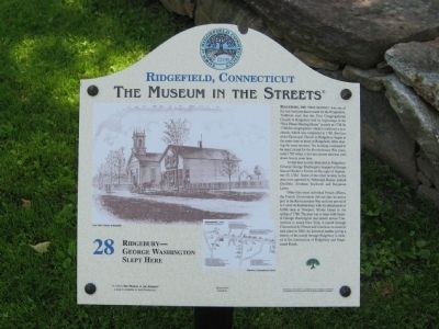
Ridgebury, "The New Patent," was one of the last land purchases made by the Proprietors. Tradition says that the First Congregational Church in Ridgebury had its beginnings in the "New Patent Meeting House" as early as 1738. In 1768 the congregation voted to construct a new church, which was completed in 1769. Services at the Episcopal Church in Ridgebury began at the same time as those in Ridgefield, often sharing the same minister. The building continued to be used, except for the Revolutionary War years, until 1789 when it fell into disuse and was torn down twenty years later.
At that time taverns abounded in Ridgebury. General George Washington stopped at Ensign Samuel Keeler's Tavern on the night of September 19, 1780. Some of the other taverns in the area were operated by Nehemiah Keeler, Icabod Doolittle, Abraham Rockwell and Benjamin Lynes.
Other than some individual French Officers, the French Government did not take an active part in the Revolutionary War until the arrival of le Comte de Rochambeau with his detachment of 6,000 men at Newport, Rhode Island in the spring of 1780. The plan was to meet with General George Washington and march across Connecticut to attack New York. A march through Connecticut by French and American re-enactors took place in 2005. An historical marker giving a history of the march through Ridgebury is located at the intersection of Ridgebury and Stagecoach Roads.
Erected by The Museum in the Streets®. (Marker Number 28.)
Topics and series. This historical marker is listed in these topic lists: Churches & Religion • Colonial Era • Settlements & Settlers • War, US Revolutionary. In addition, it is included in the Former U.S. Presidents: #01 George Washington, the George Washington Slept Here, and the The Museum in the Streets®: Ridgefield, Connecticut series lists. A significant historical date for this entry is September 19, 1870.
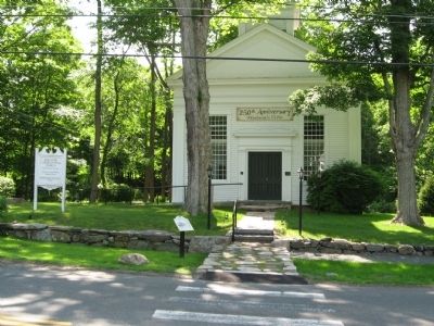
Location. 41° 21.651′ N, 73° 31.483′ W. Marker is in Ridgefield, Connecticut, in Fairfield County. Marker is at the intersection of Ridgebury Road and George Washington Highway, on the right when traveling south on Ridgebury Road. Located in front of the Ridgebury Congregational Church. Touch for map. Marker is in this post office area: Ridgefield CT 06877, United States of America. Touch for directions.
Other nearby markers. At least 8 other markers are within 4 miles of this marker, measured as the crow flies. Ridgebury Congregational Church (a few steps from this marker); Washington – Rochambeau Revolutionary Route (approx. 0.9 miles away); Peach Pond Cemetery (approx. 2.3 miles away in New York); Balanced Rock (approx. 3.1 miles away in New York); Gen. David Wooster
(approx. 3.9 miles away); Place Where Wooster Fell (approx. 3.9 miles away); Our Warning Ring (approx. 3.9 miles away in New York); June Cemetery (approx. 4 miles away in New York). Touch for a list and map of all markers in Ridgefield.
Related markers. Click here for a list of markers that are related to this marker. Take the Museum in the Streets Walking Tour in Ridgefield, Connecticut.
Credits. This page was last revised on November 25, 2021. It was originally submitted on June 20, 2010, by Michael Herrick of Southbury, Connecticut. This page has been viewed 3,017 times since then and 70 times this year. Photos: 1, 2. submitted on June 20, 2010, by Michael Herrick of Southbury, Connecticut.

