East Providence Township near Breezewood in Bedford County, Pennsylvania — The American Northeast (Mid-Atlantic)
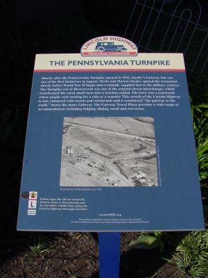
The Pennsylvania Turnpike
Lincoln Highway Heritage Corridor
Erected by a grant from the Department of Conservation and Natural Resources and a Federal Transportation Enhancement award.
Topics and series. This historical marker is listed in these topic lists: Industry & Commerce • Roads & Vehicles • Settlements & Settlers. In addition, it is included in the Lincoln Highway series list. A significant historical year for this entry is 1941.
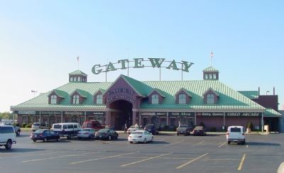
Location. 40° 0.012′ N, 78° 14.076′ W. Marker is near Breezewood, Pennsylvania, in Bedford County. It is in East Providence Township. Marker can be reached from the intersection of Lincoln Highway (U.S. 30) and the Pennsylvania Turnpike's Breezewood Interchange (Interstate 70,76), on the right when traveling west. Marker is to the right of the main doors to the Gateway Travel Plaza. Touch for map. Marker is at or near this postal address: 16537 Lincoln Hwy, Breezewood PA 15533, United States of America. Touch for directions.
Other nearby markers. At least 8 other markers are within 8 miles of this marker, measured as the crow flies. Military Convoys (here, next to this marker); Forbes Road (approx. 1.8 miles away); Highway Enterprise (approx. 3.9 miles away); Everett Area Honor Roll (approx. 6.8 miles away); Everett Veterans Memorial (approx. 6.8 miles away); a different marker also named Highway Enterprise (approx. 7.2 miles away); Our Main Street (approx. 7.3 miles away); Early Roads (approx. 7˝ miles away).
More about this marker. Interstate 70 shares the Pennsylvania Turnpike's roadway for 88 miles between Breezewood and New Stanton before continuing west on its own pavement. But in Breezewood I-70 travels for half a mile on the old Lincoln Highway (U.S. 30), complete with traffic lights and left turns into numerous parking lots before entering the turnpike using the turnpike's interchange with U.S. 30. Pennsylvania has never bothered to build an interchange between I-70 and the turnpike even though I-70 crosses the turnpike on a bridge two miles south of Breezewood. If you're traveling on I-70 to or from Washington or Baltimore, you have no excuse not to stop at The Gateway, and you should too: good food at reasonable prices 24 hours a day.
Regarding The Pennsylvania Turnpike. The earliest part of the Turnpike opened in 1940, not 1941.
Also see . . . History of the Pennsylvania Turnpike. (Submitted on May 6, 2006.)
Additional keywords. Lincoln Highway Heritage Corridor Marker
Credits. This page was last revised on February 7, 2023. It was originally submitted on May 6, 2006, by J. J. Prats of Powell, Ohio. This page has been viewed 3,604 times since then and 31 times this year. Last updated on February 23, 2021, by Carl Gordon Moore Jr. of North East, Maryland. Photos: 1, 2. submitted on May 6, 2006, by J. J. Prats of Powell, Ohio. • J. Makali Bruton was the editor who published this page.

