Near Mechanicsville in Hanover County, Virginia — The American South (Mid-Atlantic)
Balloons Over the Battlefield
Brig. Gen. Andrew A. Humphreys, Union staff officer
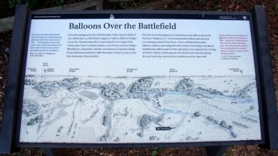
From this vantage point the Chickahominy Valley opens in front of you. Before June 27, McClellan’s engineers built 10 different bridges across the Chickahominy River connecting the two wings of the Union army. Porter’s reinforcements crossed three of those bridges: Woodbury’s, Alexander’s, and the more famous Grapevine Bridge. If you had been posted here with binoculars on June 27, you would have witnessed a historical first.
Near the Union headquarters at Trent House, two miles to the south, Professor Thaddeus S. C. Lowe launched his balloon and observed Lee massing to attack Porter here. Closer to Richmond another balloon could be seen rising above the horizon. In its basket was famed Confederate artilleryman E. Porter Alexander, who reported the crossing of Porter’s Union reinforcements. For the first and only time during the war, both sides used aerial reconnaissance at the same time.
“My first afternoon in the balloon was during the terrible battle of Gaines’s Mill….[and] while I could seldom see the troops, the smoke of the firings gave a very fair idea of the action, & I saw and signalled the crossing of Slocum’s division to reinforce Porter during the action.” Lt. Col. E. Porter Alexander, Confederate staff officer
Erected 2010 by Richmond National Battlefield Park.
Topics. This historical marker is listed in these topic lists: Air & Space • War, US Civil. A significant historical date for this entry is June 27, 1890.
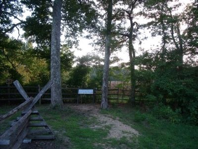
Location. 37° 34.288′ N, 77° 17.705′ W. Marker is near Mechanicsville, Virginia, in Hanover County. Marker can be reached from Watt House Road, 0.7 miles south of Cold Harbor Road (Virginia Route 156), on the right when traveling south. This marker is located on the walking trail along Boatswain Creek in the Gaines' Mill Battlefield unit of the Richmond National Battlefield Park. Touch for map. Marker is at or near this postal address: 6283 Watt House Road, Mechanicsville VA 23111, United States of America. Touch for directions.
Other nearby markers. At least 8 other markers are within walking distance of this marker. Mistaken Identity (here, next to this marker); The Cavalry Charge (a few steps from this marker); Watt Farm Road (about 500 feet away, measured in a direct line); Union Rifle Pits (about 600 feet away); Wilcox’s Alabama Brigade, (about 600 feet away); Intensity of Battle (about 600 feet away); Wilcox’s Brigade, CSA (about 700 feet away); Morell’s Division, USA (about 800 feet away). Touch for a list and map of all markers in Mechanicsville.
More about this marker. On the bottom of the panel is an illustration of the Chickahominy River valley showing the locations of several bridges and balloon positions.
Related marker. Click here for another marker that is related to this marker. Old Marker At This Location titled "The Battle Ends".
Also see . . .
1. Richmond National Battlefield Park. (Submitted on August 25, 2010, by Bernard Fisher of Richmond, Virginia.)
2. Gaines' Mill. CWSAC Battle Summary (Submitted on August 25, 2010, by Bernard Fisher of Richmond, Virginia.)
Credits. This page was last revised on November 5, 2021. It was originally submitted on August 25, 2010, by Bernard Fisher of Richmond, Virginia. This page has been viewed 1,099 times since then and 18 times this year. Photos: 1, 2. submitted on August 25, 2010, by Bernard Fisher of Richmond, Virginia.

