Eminence in Shannon County, Missouri — The American Midwest (Upper Plains)
Eminence
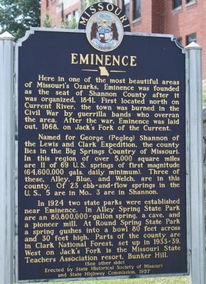
Here in one of the most beautiful areas of Missouri's Ozarks, Eminence was founded as the seat of Shannon County after it was organized, 1841. First located north of Current River, the town was burned in the Civil War by guerrilla bands who overran the area. After the war, Eminence was laid out, 1868, on Jack's Fork of the current.
Named for George (Pegleg) Shannon of the Lewis and Clark Expedition, the county lies in the Big Springs Country of Missouri. In this region of over 5,000 square miles are 11 of 69 U.S. springs of first magnitude (64,600,000 gals. daily minimum). Three of these, Alley, Blue, and Welch, are in this county. Of 23 ebb-and-flow springs in the U.S., 5 are in Mo, 3 are in Shannon.
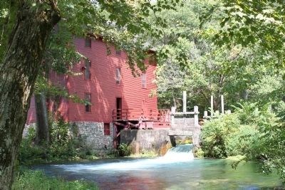
In 1924 two state parks were established near Eminence. In Alley Spring State Park are an 80,800,000-gallon spring, a cave, and a pioneer mill. At Round Spring State Park a spring gushes into a bowl 80 feet across and 30 feet high. Parts of the county are in Clark National Forest, set up in 1933-39. West on Jack's Fork is the Missouri State Teachers Association resort, Bunker Hill.
(Back):
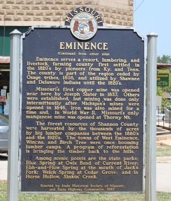
Missouri's first copper mine was opened near here by Joseph Slater in 1837. Others were established, but mining was done only intermittently after Michigan's mines were opened in 1846. Iron was also mined for a time and, in World War II, Missouri's only manganese mine was opened at Thorny Mt.
The forest resources of Shannon County were harvested by the thousands of acres by big lumber companies between the 1880's and the 1920's. The towns of West Eminence, Winona, and Birch Tree were once booming lumber camps. A program of reforestation is bringing the timber back to the hills.
Among scenic points are the state parks: Blue Springs at Owls Bend of Current River; Ebb-and-Flow Spring at the mouth of Jack's Fork; Welch Spring at Cedar Grove; and in Horse Hollow, Sinkin' Creek.
Erected 1957 by State Historical Society of Missouri and State Highway Commission.
Topics and series. This historical marker is listed in these topic lists: Industry & Commerce • Native Americans • Natural Features • Settlements & Settlers • War, US Civil. In addition, it is included in the Missouri, The State Historical Society of series list. A significant historical year for this entry is 1841.
Location. 37° 8.918′ N, 91° 21.474′ W. Marker is in Eminence, Missouri, in Shannon County. Marker is at the intersection of Main Street (State Highway 19) and Missouri Avenue, on the right when traveling south on Main Street. Located in front of the Shannon County Courthouse. Touch for map. Marker is in this post office area: Eminence MO 65466, United States of America. Touch for directions.
Other nearby markers. At least 3 other markers are within 14 miles of this marker, measured as the crow flies. Alley Spring (approx. 4.6 miles away); The Ancient Ozarks (approx. 9 miles away); Veterans Memorial (approx. 13.2 miles away).
Also see . . . Ozark National Scenic Riverways. The National Park Service now administers most of the "spring" parks mentioned on the marker. (Submitted on September 19, 2010, by Craig Swain of Leesburg, Virginia.)
Additional commentary.
1. Corrections to the Marker
Since the time this marker was erected, several changes were made to the parks and forests in Shannon County. Many of the state parks related to the springs, mentioned in the text, were transferred to the National Park Service when the Ozark National Scenic Riverways Park was created between 1964-71. Clark National Forest was consolidated with Mark Twain National Forest in 1973-6.
— Submitted September 19, 2010, by Craig Swain of Leesburg, Virginia.
Credits. This page was last revised on June 16, 2016. It was originally submitted on September 19, 2010, by Craig Swain of Leesburg, Virginia. This page has been viewed 2,108 times since then and 130 times this year. Photos: 1, 2, 3. submitted on September 19, 2010, by Craig Swain of Leesburg, Virginia. 4. submitted on September 20, 2010, by Craig Swain of Leesburg, Virginia.


