Palmyra in Marion County, Missouri — The American Midwest (Upper Plains)
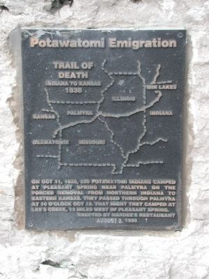
Potawatomi Emigration
Trail of Death
Inscription.
Indiana to Kansas 1838
On Oct. 11, 1838, 850 Potawatomi Indians camped at Pleasant Spring near Palmyra on the forced removal from Northern Indiana to Eastern Kansas. They passed through Palmyra at 10 o'clock October 12. That night they camped at Lee's Creek, 13 miles west of Pleasant Spring.
Erected 1995 by Hardee's Restaurant.
Topics and series. This historical marker is listed in these topic lists: Civil Rights • Education • Native Americans. In addition, it is included in the Potawatomi Trail of Death series list. A significant historical date for this entry is October 12, 1752.
Location. 39° 48.006′ N, 91° 31.097′ W. Marker is in Palmyra, Missouri, in Marion County. Marker is on East Main Cross, 0.1 miles west of US 61 and US 24 (U.S. 61/24), on the right when traveling west. The marker is located to the left of the front door of Hardee's Restaurant. The restaurant is on the west side of US 61/24 on Main Cross Street. The restaurant is visible from the highway. Touch for map. Marker is at or near this postal address: 500 East Main Cross, Palmyra MO 63461, United States of America. Touch for directions.
Other nearby markers. At least 8 other markers are within walking distance of this marker. Palmyra (approx. ¼ mile away); George Shannon (approx. ¼ mile away); Palmyra Confederate Monument (approx. ¼ mile away); Palmyra Massacre (approx. 0.3 miles away); Big Spring (approx. 0.4 miles away); Gardner House (approx. 0.4 miles away); Speigle House (approx. 0.4 miles away); Home of Jane Darwell (approx. 0.9 miles away). Touch for a list and map of all markers in Palmyra.
Regarding Potawatomi Emigration. The marker contains a map of the central United States with the trail shown starting in Twin Lakes, Indiana, crossing Illinois and Missouri, and ending at Osawatomie, Kansas.
Additional keywords. Map Twin Lakes Osawatomie
Credits. This page was last revised on March 29, 2024. It was originally submitted on July 19, 2010, by New Berlin Area Historical Society of New Berlin, Illinois. This page has been viewed 1,801 times since then and 50 times this year. Last updated on October 1, 2010. Photos: 1, 2, 3. submitted on July 19, 2010, by New Berlin Area Historical Society of New Berlin, Illinois. 4. submitted on March 29, 2024, by Jason Voigt of Glen Carbon, Illinois. • Bill Pfingsten was the editor who published this page.


