South Deerfield in Franklin County, Massachusetts — The American Northeast (New England)
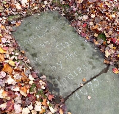
Bloody Brook Stone Slab
of
Capt. Lathrop
and
Men Slain
by the
Indians
1675
Topics. This historical marker is listed in these topic lists: Colonial Era • Native Americans • Wars, US Indian • Waterways & Vessels. A significant historical year for this entry is 1675.
Location. 42° 28.919′ N, 72° 36.232′ W. Marker is in South Deerfield, Massachusetts, in Franklin County. Marker is on North Main Street, on the right when traveling north. Touch for map. Marker is at or near this postal address: 100 North Main Street, South Deerfield MA 01373, United States of America. Touch for directions.
Other nearby markers. At least 8 other markers are within 5 miles of this marker, measured as the crow flies. Bloody Brook Monument (about 400 feet away, measured in a direct line); SGT. Gregory Allen Belanger (approx. 3.2 miles away); Old Deerfield (approx. 4.1 miles away); Memorial Hall (approx. 4.2 miles away); Godfrey Nims (approx. 4.2 miles away); Benjamin Barrett (approx. 4.2 miles away); Wells-Thorn House (approx. 4.3 miles away); Lucy Terry Prince / Caesar (approx. 4.3 miles away).
Regarding Bloody Brook Stone Slab. This horizontal slab is “perhaps the oldest surviving monument to veterans in America,” write Eric B. Schultz and Michael J. Tougias in their 1999 book, King Philip’s War. It predates by many years the Bloody Brook Monument (see Other Nearby Markers, above). But it had been moved so many times that in 1835, when construction started on that structure, the town formed a committee to identify the precise location of the mass grave. “Guided by ‘tradition and some aged people’ the committee located the spot,” Schultz and Tougias note.
Also see . . . A Brief History. Short summary of King Philip’s War. (Submitted on November 4, 2010, by Roger W. Sinnott of Chelmsford, Massachusetts.)
Credits. This page was last revised on October 14, 2020. It was originally submitted on November 4, 2010, by Roger W. Sinnott of Chelmsford, Massachusetts. This page has been viewed 1,649 times since then and 78 times this year. Photos: 1, 2. submitted on November 4, 2010, by Roger W. Sinnott of Chelmsford, Massachusetts. • Bill Pfingsten was the editor who published this page.

