Petersburg, Virginia — The American South (Mid-Atlantic)
Fort Hays
A Silent Witness
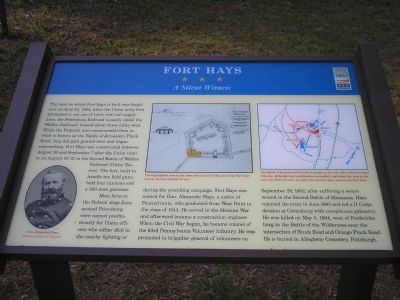
Most forts in the Federal siege lines around Petersburg were named posthumously for Union officers who either died in nearby fighting or during the preceding campaign. Fort Hays was named for Gen. Alexander Hays, a native of Pennsylvania, who graduated from West Point in the class of 1844. He served in the Mexican War and afterward became a construction engineer. When the Civil War began, he became colonel of the 63rd Pennsylvania Volunteer Infantry. He was promoted to brigadier general of volunteers on September 29, 1862, after suffering a severe wound in the Second Battle of Manassas. Hayes rejoined the army in June 1863 and led a II Corps division at Gettysburg with conspicuous gallantry. He was killed on May 5, 1864, west of Fredericksburg in the Battle of the Wilderness near the intersection of Brock Road and Orange Plank Road. He is buried in Allegheny Cemetery, Pittsburgh.
Erected by Virginia Civil War Trails.
Topics and series. This historical marker is listed in this topic list: War, US Civil. In addition, it is included in the Virginia Civil War Trails series list. A significant historical month for this entry is May 1724.
Location. 37° 10.862′ N, 77° 22.945′ W. Marker is in Petersburg, Virginia. Marker is on Flank Road, on the right when traveling west. Marker is located on the north side of Flank Road, midway between Jerusalem Plank Road (US 301) and Birdsong Road (CR 629). Flank Road is part of Petersburg National Battlefield. Touch for map. Marker is in this post office area: Petersburg VA 23805, United States of America. Touch for directions.
Other nearby markers. At least 8 other markers are within 2 miles of this marker, measured as the crow flies. The Battle of Jerusalem Plank Road (approx. 0.7 miles away); a different marker also named The Battle of Jerusalem Plank Road (approx. 0.7 miles away); Fort Davis (approx. 0.9 miles away); a different marker also named Fort Davis (approx. 0.9 miles away); Lincoln In Petersburg (approx. 1˝ miles away); Pennsylvania Monument (approx. 1˝ miles away); Col. George W. Gowen Monument (approx. 1˝ miles away); Battery 31 (approx. 1.6 miles away). Touch for a list and map of all markers in Petersburg.
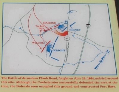
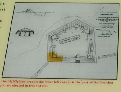
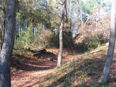
More about this marker. On the lower left is a portrait of Gen. Alexander Hays. In the center is an engineering plan of the fort, with a highlight over the portion of the fort visible today. A map on the right details, "The Battle of Jerusalem Plank Road, fought on June 22," which "swirled around this site. Although the Confederates successfully defended the area at the time, the Federals soon occupied this ground and constructed Fort Hays."
Related markers. Click here for a list of markers that are related to this marker. Markers and monuments to General Hays
Also see . . .
1. The Civil War Siege of Petersburg. (Submitted on November 28, 2007, by Craig Swain of Leesburg, Virginia.)
2. General Alexander Hays. (Submitted on November 28, 2007, by Craig Swain of Leesburg, Virginia.)
Credits. This page was last revised on February 2, 2023. It was originally submitted on November 18, 2007, by Bill Coughlin of Woodland Park, New Jersey. This page has been viewed 2,535 times since then and 66 times this year. Last updated on November 28, 2007, by Bill Coughlin of Woodland Park, New Jersey. Photos: 1. submitted on November 18, 2007, by Bill Coughlin of Woodland Park, New Jersey. 2, 3. submitted on December 24, 2008, by Craig Swain of Leesburg, Virginia. 4. submitted on November 18, 2007, by Bill Coughlin of Woodland Park, New Jersey. 5, 6. submitted on December 24, 2008, by Craig Swain of Leesburg, Virginia. 7. submitted on November 18, 2007, by Bill Coughlin of Woodland Park, New Jersey. • Craig Swain was the editor who published this page.
