Near Las Cruces in Doña Ana County, New Mexico — The American Mountains (Southwest)
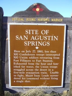
Site of San Agustín Springs
Topics. This historical marker is listed in this topic list: War, US Civil. A significant historical date for this entry is July 27, 1861.
Location. 32° 25.809′ N, 106° 35.101′ W. Marker is near Las Cruces, New Mexico, in Doña Ana County. Marker is on U.S. 70 at milepost 177, on the right when traveling west. Touch for map. Marker is in this post office area: Las Cruces NM 88011, United States of America. Touch for directions.
Other nearby markers. At least 8 other markers are within 14 miles of this marker, measured as the crow flies. San Augustín Pass (approx. 1.2 miles away); Nike Hercules Missile (approx. 1.3 miles away); White Sands Missile Range (approx. 7 miles away); Pat Garrett Murder Site (approx. 9.2 miles away); America's First Battle of World War II: The Philippines (approx. 11.7 miles away); Heroes of Bataan (approx. 11.7 miles away); The Historic Green Bridge (approx. 12 miles away); The Branigan Building (approx. 14 miles away). Touch for a list and map of all markers in Las Cruces.
Credits. This page was last revised on June 16, 2016. It was originally submitted on November 18, 2010, by Bill Kirchner of Tucson, Arizona. This page has been viewed 1,382 times since then and 53 times this year. Photos: 1, 2, 3. submitted on November 18, 2010, by Bill Kirchner of Tucson, Arizona. • Craig Swain was the editor who published this page.


