Laurel in Henrico County, Virginia — The American South (Mid-Atlantic)
Henrico County
Virginia’s Second Settlement
In 1934, exactly 300 years after becoming one of the original shires, Henrico became the first county in Virginia to adopt the county manager form of government. That year, the Board of Supervisors appointed Willard F. Day County Manager. Since then, the Board of Supervisors has been responsible for policy making while the County Manager has been responsible for the day-to-day operations of county services.
Erected 1997 by County of Henrico Division of Recreation and Parks.
Topics. This historical marker is listed in these topic lists: Colonial Era • Exploration • Settlements & Settlers. A significant historical year for this entry is 1611.
Location. 37° 37.725′ N, 77° 31.032′ W. Marker is in Laurel, Virginia, in Henrico County. Marker can be reached from Prince Henry Drive near East Parham Road. This panel is located outside of the Court Building at the Henrico Government Center. Touch for map. Marker is at or near this postal address: 4301 East Parham Road, Henrico VA 23228, United States of America. Touch for directions.
Other nearby markers. At least 8 other markers are within 3 miles of this marker, measured as the crow flies. The Early Courthouses in Varina (here, next to this marker); The Courthouse Today (here, next to this marker); The Courthouses in Richmond (here, next to this marker); Laurel Historic District (approx. 1.1 miles away); Virginia Home for Boys (approx. 1.4 miles away); Bethlehem Baptist Church (approx. 1.6 miles away); Outer Defenses (approx. 1.8 miles away); Skipwith Academy (approx. 2.2 miles away). Touch for a list and map of all markers in Laurel.
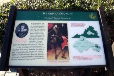
More about this marker. On the upper left is a portrait of "Henry Frederick, Prince of Wales, as a young man, ca. 1600. Thomas Dale named Henricus in his honor, later to be known as Henrico County." Library of Virginia
In the center is a painting with the caption, "Sir Thomas Dale led the expedition that established the Virginia Company’s second settlement." Virginia Museum of Fine Arts
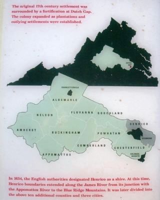
On the right is a map with the caption, "The original 17th century settlement was surrounded by a fortification at Dutch Gap. The colony expanded as plantations and outlying settlements were established." A second map carries the caption, "In 1634, the English authorities designated Henrico as a shire. At this time, Henrico boundaries extended along the James River from its junction with the Appomattox River to the Blue Ridge Mountains. It was later divided into the above ten additional counties and three cities."
Also see . . . Henrico County History. (Submitted on January 14, 2011.)
Credits. This page was last revised on April 26, 2022. It was originally submitted on January 14, 2011, by Bernard Fisher of Richmond, Virginia. This page has been viewed 926 times since then and 19 times this year. Photos: 1, 2, 3, 4. submitted on January 14, 2011, by Bernard Fisher of Richmond, Virginia.


