Saint Anthony Main in Minneapolis in Hennepin County, Minnesota — The American Midwest (Upper Plains)
The Pillsbury A Mill
— Saint Anthony Falls Heritage Trail —
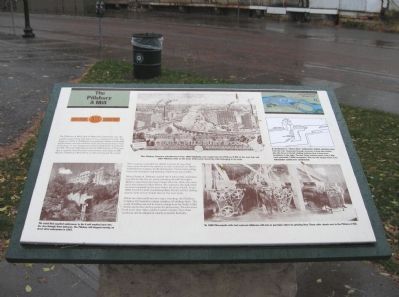
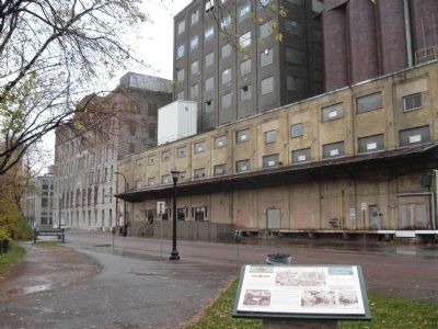
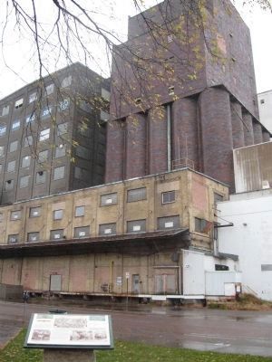
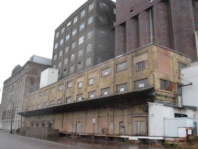
The Pillsbury A Mill, built of Platteville limestone, was the world’s largest flour mill when it was completed in 1881. The design by LeRoy S. Buffington is considered a classic of industrial architecture, and the interior of the mill boasted state-of-art technology. It was designated a National Historic Landmark in 1966. The mill originally produced 5,000 barrels of flour per day, a capacity that was later increased to more than 17,000 barrels. Pillsbury’s Best Flour is still sold around the world.
The company rewarded its skilled workers in ways that were years ahead of the practice in other industries. In 1883 it established an employee profit-sharing plan. Unions representing most mill employees negotiated an eight hour day in 1902.
When Charles A. Pillsbury opened the A mill in 1881, machinery was driven directly by water entering the mill through a 400-foot canal from the river. Closed off in the 1950s, the canal still exists beneath Main Street. The tailraces through which its water emptied can be seen below the river’s bank. In the 1880s four flour mills stood along Main Street, but the milling district here never rivaled that on the west bank.
While the other mills are no longer standing, the Pillsbury company still operates a large complex of buildings here. The sound of milling can still be heard coming from the South A Mill. Trucks and trains deliver grain for processing. The elevators hold more than three million bushels of grain. New food products are developed in nearby research facilities.
Erected by the St. Anthony Falls Heritage Board.
Topics and series. This historical marker is listed in this topic list: Industry & Commerce. In addition, it is included in the National Historic Landmarks series list. A significant historical year for this entry is 1881.
Location. 44° 58.98′ N, 93° 15.12′ W. Marker is in Minneapolis, Minnesota, in Hennepin County. It is in Saint Anthony Main. Marker is on Main Street Southeast east of 3rd Avenue Southeast, on the right when traveling east. Touch for map. Marker is at or near this postal address: 301 Main Street Southeast, Minneapolis MN 55414, United States of America. Touch for directions.
Other nearby markers. At least 8 other markers are within walking distance of this marker. A different marker also named Pillsbury A Mill (within shouting distance of this marker); Pettingill's Wonderful Water (about 400 feet away, measured in a direct line); Follow the Water: Part 2 - Forebay to Tailrace (about 400 feet away); Franklin Steele (about 500 feet away); Portaging Around the Falls (about 600 feet away); Marcy~Holmes (about 700 feet away); Layers of History (about 700 feet away); Power on the East Side (about 700 feet away). Touch for a list and map of all markers in Minneapolis.
Regarding The Pillsbury A Mill.
[photo captions, clockwise, starting from the lower left]
The canal that supplied waterpower to the A mill emptied back into the river through these tailraces. The Pillsbury mill stopped running on direct drive waterpower in 1955.
This Pillsbury Company advertisement from 1885 highlights and exaggerates the Pillsbury A Mill on the east side and other Pillsbury mills on the west, deliberately obscuring mills belonging to its rivals.
A mechanical or "direct drive" waterpower system, showing water from the river channeled through raceways to drop into turbine pits, the force of its fall rotating turbines that in turn drove machinery in the mills. The two Victor turbines used in the A mill each generated 1,200 horsepower. This was the largest direct drive waterpower system ever constructed.
By 1880 Minneapolis mills had replace millstones with iron or porcelain rollers for grinding flour. These roller stands were in the Pillsbury A Mill.
Also see . . .
1. Pillsbury A Mill. Wikipedia entry. (Submitted on March 5, 2011.)
2. Minneapolis Flour Milling Boom. Mill City Museum website entry (Submitted on July 7, 2023, by Larry Gertner of New York, New York.)
Credits. This page was last revised on July 7, 2023. It was originally submitted on March 5, 2011, by Keith L of Wisconsin Rapids, Wisconsin. This page has been viewed 1,199 times since then and 60 times this year. Photos: 1, 2, 3, 4. submitted on March 6, 2011, by Keith L of Wisconsin Rapids, Wisconsin.


