McAfee in Vernon Township in Sussex County, New Jersey — The American Northeast (Mid-Atlantic)
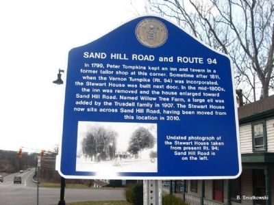
Sand Hill Road and Route 94
Erected 2010 by State of New Jersey.
Topics. This historical marker is listed in these topic lists: Agriculture • Roads & Vehicles • Settlements & Settlers. A significant historical year for this entry is 1799.
Location. 41° 11.511′ N, 74° 30.536′ W. Marker is in Vernon Township, New Jersey, in Sussex County. It is in McAfee. Marker is at the intersection of McAfee Vernon Road (Route 94) and Sand Hill Road, on the right when traveling west on McAfee Vernon Road. Touch for map. Marker is at or near this postal address: 190 McAfee Vernon Road, Hamburg NJ 07419, United States of America. Touch for directions.
Other nearby markers. At least 8 other markers are within 6 miles of this marker, measured as the crow flies. Cedar Crest Farm (approx. 1.2 miles away); Denton-Wallace House (approx. 1.4 miles away); St. Thomas Episcopal Church (approx. 1.4 miles away); Price's Switch Schoolhouse (approx. 3.8 miles away); Joseph Sharp's Iron Works (approx. 4.7 miles away); High Breeze Farm (approx. 5.1 miles away); George Washington Encampment (approx. 5.2 miles away); Sussex Borough, New Jersey (approx. 5.3 miles away). Touch for a list and map of all markers in Vernon Township.
Credits. This page was last revised on August 28, 2023. It was originally submitted on March 23, 2011, by Brian Sniatkowski of Kinnelon, New Jersey. This page has been viewed 917 times since then and 29 times this year. Photo 1. submitted on March 23, 2011, by Brian Sniatkowski of Kinnelon, New Jersey. • Syd Whittle was the editor who published this page.
Editor’s want-list for this marker. Wide area view of the marker and its surroundings. • Photo of the Stewart House. • Can you help?
