Waynesboro, Virginia — The American South (Mid-Atlantic)
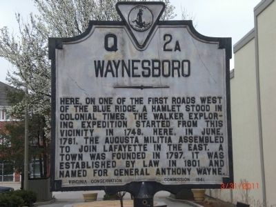
Waynesboro
Erected 1941 by Virginia Conservation Commission. (Marker Number Q-2a.)
Topics and series. This historical marker is listed in these topic lists: Colonial Era • Settlements & Settlers • War, US Revolutionary. In addition, it is included in the Virginia Department of Historic Resources (DHR) series list. A significant historical month for this entry is June 1781.
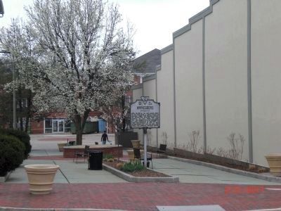
Location. 38° 4.111′ N, 78° 53.309′ W. Marker is in Waynesboro, Virginia. Marker is on West Main St (U.S. 340), on the left when traveling east. Marker is on West Main St in downtown Waynesboro, at the entrance to a pedestrian alley that leads to Spring Lane. Touch for map. Marker is in this post office area: Waynesboro VA 22980, United States of America. Touch for directions.
Other nearby markers. At least 8 other markers are within walking distance of this marker. Fishburne Military School (about 500 feet away, measured in a direct line); a different marker also named Waynesboro (about 700 feet away); River Crossings & Bridges (approx. 0.2 miles away); Ecology of the South River (approx. ¼ mile away); William H. Harman Monument (approx. ¼ mile away); Wooden Water Pipe (approx. 0.4 miles away); Plumb House (approx. 0.4 miles away); W. J. Loth (approx. half a mile away). Touch for a list and map of all markers in Waynesboro.
More about this marker. This is one of two markers for the city of Waynesboro. The other (Q-2b) is located in Constitution Park at the foot of West Main St.
Credits. This page was last revised on June 16, 2016. It was originally submitted on March 31, 2011, by Jim Wilson of Waynesboro (Independent City), Virginia. This page has been viewed 793 times since then and 27 times this year. Photos: 1, 2. submitted on March 31, 2011, by Jim Wilson of Waynesboro (Independent City), Virginia. • Bill Pfingsten was the editor who published this page.

