Lowell in Middlesex County, Massachusetts — The American Northeast (New England)
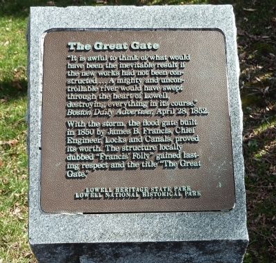
The Great Gate
“It is awful to think of what would have been the inevitable result if the new works had not been constructed … A mighty and uncontrollable river would have swept through the heart of Lowell, destroying everything in its course.”
Boston Daily Advertiser, April 28, 1852.
With the storm, the flood gate built in 1850 by James B. Francis, Chief Engineer, Locks and Canals, proved its worth. The structure locally dubbed “Francis’ Folly” gained lasting respect and the title “The Great Gate.”
Lowell National Historical Park
Topics. This historical marker is listed in these topic lists: Charity & Public Work • Waterways & Vessels. A significant historical month for this entry is April 1836.
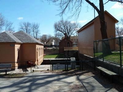
Location. 42° 38.593′ N, 71° 19.768′ W. Marker is in Lowell, Massachusetts, in Middlesex County. Marker can be reached from Broadway Street. Marker is in Francis Gate Park between the Great Gate and Lock House buildings. It is off to the left side of Broadway Street when traveling east, just before the bridge over the Pawtucket Canal. Touch for map. Marker is in this post office area: Lowell MA 01854, United States of America. Touch for directions.
Other nearby markers. At least 8 other markers are within walking distance of this marker. "Francis’ Folly" (a few steps from this marker); Working the Water (approx. 0.4 miles away); Suffolk Mill (approx. 0.8 miles away); Keepers of the Gate (approx. 0.8 miles away); Blending Old and New (approx. 0.8 miles away); Stele for the Merrimack (approx. 0.8 miles away); "Quiet as the Grave" (approx. 0.8 miles away); Lowell Manufacturing Company (approx. 0.8 miles away). Touch for a list and map of all markers in Lowell.
Regarding The Great Gate. Lowell, in northern Massachusetts, is one of the great mill towns that grew up in New England during the 19th century. Already situated at a bend in the Merrimack River, the city built a 5.6-mile network of canals in 1820–40 to divert water from the Merrimack through the city streets for powering the various mill buildings. These waterways are fed by an initial one, called the Pawtucket Canal.
English-born engineer James B. Francis (1815–92) realized that flood conditions on the Merrimack could send water surging through the Pawtucket Canal and threaten the entire downtown area of Lowell. He therefore designed the Guard Locks for this canal, including a 20-ton gate suspended above the waterway by an iron

Photographed By Roger W. Sinnott, April 18, 2011
2. View of Guard Locks from the West
The marker is seen in the foreground of this picture, which shows the three main structures of the Guard Locks on the Pawtucket Canal. They consist of the Great Gate (right), Gate House (center, in the distance), and Lock House (left). This last building has a light-duty gate that can be swung open or closed by means of the red wooden beams that project from its corners, but this gate would not hold back a flood. Canal water flows to the right.
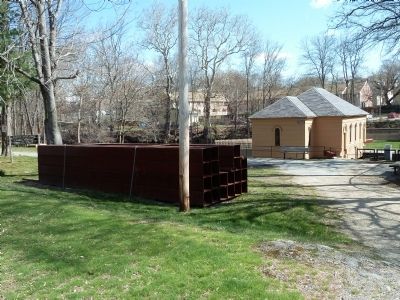
The Great Gate has been dropped only twice, in 1852 and then again in 1936. During the more recent floods of 2006 and 2007, a crane was used to lower a barricade of hollow steel beams on the upstream side of the Great Gate. This proved less problematic than it would have been to drop the gate itself, then raise it again when the flood danger had passed.
Also see . . . Wikipedia entry for James B. Francis. (Submitted on April 28, 2011, by Roger W. Sinnott of Chelmsford, Massachusetts.)

Photographed By Roger W. Sinnott, April 18, 2011
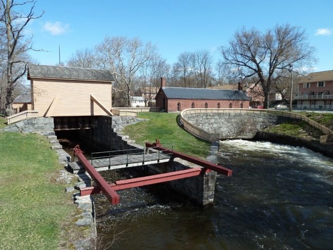
3. View from the Broadway Street Bridge
At left is the Great Gate, normally raised (as here), but which can be dropped in emergency flood conditions. At right is the original Gate House, which was used to adjust the flow of water into the Lowell canal system.

Photographed By Roger W. Sinnott, April 18, 2011
4. Steel Beams for New Barricade
These 19 hollow steel beams, each 16" square and 28' 3" long, are permanently staged next to the Great Gate. When lowered by crane into slots cut in the stone walls next to the Great Gate building, they serve the same function as dropping the gate would. This alternative method was used during flood threats in 2006 and 2007.
Credits. This page was last revised on October 25, 2020. It was originally submitted on April 28, 2011, by Roger W. Sinnott of Chelmsford, Massachusetts. This page has been viewed 940 times since then and 57 times this year. Photos: 1, 2, 3, 4. submitted on April 28, 2011, by Roger W. Sinnott of Chelmsford, Massachusetts. • Bill Pfingsten was the editor who published this page.
