Leavenworth in Leavenworth County, Kansas — The American Midwest (Upper Plains)
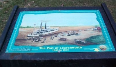
The Port of Leavenworth
1854 to 1875
— Historic Wayside Tour #1 —
In 1854 the river was the freeway of commerce, and every stable landing was a natural stop. The Missouri bends in at the Leavenworth area, and the current runs along a natural limestone bluff for some miles. A small creek cut through that bluff at this point and carved out a perfect, natural riverboat landing. This Landing was the heart of old Leavenworth. The natural landscape, transportation and business combined to made Leavenworth the largest and most important city on the early Western Plains. English visitor Thomas Gladstone described the scene this way: "A spot where the banks of the Missouri are less elevated and abrupt has been wisely chosen for the site of the city of Leavenworth. Landing from the river, there is first a broad levee of about half a mile, with a frontage of stores and warehouses full of bustle and activity. The levee is the natural river bank, ... against the steep acclivity of which the steamboat is thrust to discharge itself of its freight and passengers.
The quay is broad, being designed to receive all the business of the place and of the country behind, which receives its supplies through Leavenworth. At the time of my visit, goods of every kind lay in piles upon the quay, while the road was further blocked up with long wagons, each with six or more yoke of oxen, preparing to cross the plains."
The river was frequently closed by ice in the winter, but during the shipping season the port was very busy. In 1865 over 400 boats landed here, from which one firm alone hauled off over 50,000 tons of supplies. The passengers and supplies stopped here because of the excellent overland connections available. It was the jumping off point for overland travel to the vast west.
The Levee was a natural site for commerce and the home of many business pioneers. The first doctor's office in Kansas was near here, as were the first newspaper, first merchant and first manufacturer. In 1870 there were 106 manufacturers in Leavenworth, many clustered in this area.
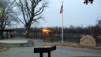
In the mid 20th century the landing was unused and all but ignored. But in 1997 the area was once more brought back into focus with the opening of the beautiful Leavenworth Landing Park. It celebrates the natural beauty of the riverfront while calling to mind its rich history as a center for trade and transportation in the old west.
Erected by City of Leavenworth. (Marker Number 1.)
Topics. This historical marker is listed in these topic lists: Communications • Industry & Commerce • Settlements & Settlers • Waterways & Vessels. A significant historical year for this entry is 1854.
Location. 39° 19.071′ N, 94° 54.51′
W. Marker is in Leavenworth, Kansas, in Leavenworth County. Marker is in Leavenworth Landing Park, about 200 feet east of the intersection of Esplanade and Cherokee Streets. Touch for map. Marker is in this post office area: Leavenworth KS 66048, United States of America. Touch for directions.
Other nearby markers. At least 8 other markers are within walking distance of this marker. Leavenworth Landing Park (a few steps from this marker); First Meeting of the Methodist Church (a few steps from this marker); Sisters of Charity (within shouting distance of this marker); Riverfront Community Center (about 400 feet away, measured in a direct line); Leavenworth's Union Depot (about 400 feet away); Law Offices of Sherman, Ewing, and McCook (about 500 feet away); General William Tecumseh Sherman (about 500 feet away); The Great Railroad Era (about 500 feet away). Touch for a list and map of all markers in Leavenworth.
More about this marker. The marker is one of a series of audio historic wayside markers - push a button on the marker and the narration (transcribed above) is given.
Also see . . .
1. The River Connection Tour. (Submitted on May 3, 2011, by William Fischer, Jr. of Scranton, Pennsylvania.)
2. Leavenworth, Kansas. (Submitted on May 4, 2011, by William Fischer, Jr. of Scranton, Pennsylvania.)
3. Leavenworth Historic Wayside Tour. (Submitted on May 4, 2011, by William Fischer, Jr. of Scranton, Pennsylvania.)
Credits. This page was last revised on June 16, 2016. It was originally submitted on May 3, 2011, by William Fischer, Jr. of Scranton, Pennsylvania. This page has been viewed 754 times since then and 31 times this year. Photos: 1, 2. submitted on May 3, 2011, by William Fischer, Jr. of Scranton, Pennsylvania.

