Knoxville in Knox County, Tennessee — The American South (East South Central)
Back Door to Knoxville
Two months prior to the Siege of Knoxville, Confederate troops under General Braxton Bragg defeated Federal forces at the bloody battle of Chickamauga and then laid siege to the Federal forces which had retreated to Chattanooga. Confederate Major General James Longstreet, during the relative inactivity of the siege, was ordered to march on Knoxville with his First Corps of the Army of Northern Virginia. His orders were to capture or drive out Major General Ambrose E. Burnside and the Army of the Ohio. Longstreet’s cavalry under Major General Joseph Wheeler was ordered to push through Blount County and attack the heights on the Holston (now Tennessee) River opposite Knoxville. If the Confederates could capture these heights, Knoxville would be at their mercy.
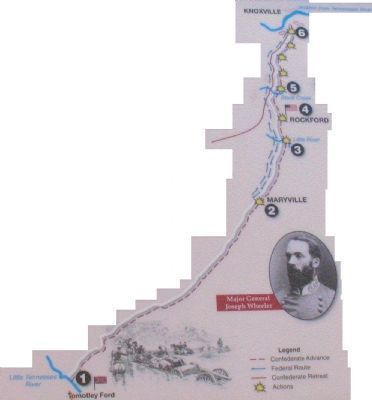
During the night of November 13, the Confederate cavalry forded the Little Tennessee River at Tomotley Ford undetected [1] and sped through the darkness toward Maryville where they expected to find the Federal Cavalry headquarters. On the dark, rainy morning of November 14, the Confederate whirlwind blew into the Federal camp at Maryville [2], scattering the members of the 11th KY Cavalry in all directions. Many escaped in the confusion, but 150 were eventually rounded up by the Confederates.
Federal cavalry headquarters was at Maryville until Brigadier General William Price Sanders decided his position was too exposed due to the “terrible number of roads leading to this place” and the Little River at his back. Sanders moved his headquarters a few miles north to the little village of Rockford [4], leaving only one Kentucky brigade at Maryville as an outpost. On the morning of the 14th, Sanders and his men awoke to the distant sound of muskets and immediately rode toward the action. The Confederates, expecting their arrival, had deployed for the onslaught. The charging Federals found themselves taking withering fire from front and both flanks, forcing them to withdraw.
The Federals crossed Little River [3], and rallied on the north bank awaiting the Confederate troops. Wheeler failed to follow up on his success, unaware that his force of more than 4,000 horsemen greatly outnumbered Sanders’ 1,500 troopers. The next morning “Fightin’ Joe” Wheeler’s men advanced and crossed Little River to find the Federals prepared for their attack. Sanders’ tenacious cavalrymen fought, withdrew to the next defensible position, and fought again. When the Confederates reached Stock Creek [5], they discovered the bridge partially destroyed and the creek too deep for horses to ford. Sanders’ Cavalry had taken a “strong and commanding” position on high ground on the opposite bank. Wheeler dismounted about half his force, crossed the creek and forced his way uphill under heavy rifle and artillery fire, finally forcing Sanders’ withdrawal.
After repairing the bridge, Wheeler crossed his force and once again attacked the stubborn Federals who fought and withdrew only to appear on the next ridge, and the next. The rolling battle continued up to the base of the heights opposite Knoxville [6].
Suddenly the Confederates realized that they were no longer facing cavalry and a few pieces of field artillery, but infantry and entrenched artillery as well. From their commanding heights the Federals fired down on the Confederates. Since it was late in the afternoon, the contest lasted only a short time before Wheeler decided to pull his troops back and access the situation.
On the morning of November 16th the Confederates returned and once again began an exchange of shots with the Federals. However, Wheeler soon became convinced that storming the steep slopes would be too costly in both time and manpower. He pulled back his troops and crossed the Holston near the community of Louisville, joining Longstreet in his march on Knoxville.
The determined actions of Sanders’ cavalry and the staunch defense of the hasty earthworks at Fort Dickerson had closed the back door to Knoxville. In the coming days the rudimentary earthworks grew, creating not only Fort Dickerson, but also Fort Higley and Fort Stanley. Knoxville’s back door was secure.
Topics. This historical marker is listed in this topic list: War, US Civil. A significant historical date for this entry is November 13, 1864.
Location. 35° 56.709′ N, 83° 54.734′ W. Marker is in Knoxville, Tennessee, in Knox County. Marker is on Chapman Hwy SW north of Woodlawn Pike SE, on the left when traveling north. Touch for map. Marker is in this post office area: Knoxville TN 37920, United States of America. Touch for directions.
Other nearby markers. At least 8 other markers are within walking distance of this marker. Fort Dickerson (here, next to this marker); a different marker also named Fort Dickerson (approx. 0.3 miles away); Forts Dickerson and Stanley (approx. 0.3 miles away); Fort Dickerson 1863–64 (approx. 0.3 miles away); Civil War Knoxville (approx. 0.3 miles away); The 1863 Siege of Knoxville (approx. 0.3 miles away); a different marker also named Fort Dickerson (approx. 0.3 miles away); a different marker also named Fort Dickerson (approx. 0.4 miles away). Touch for a list and map of all markers in Knoxville.
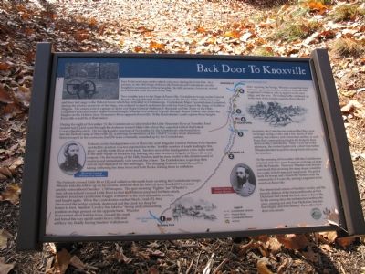
More about this marker. Marker has a photograph of an artillery piece in the upper left, a portrait of Brigadier General William Price Sanders on the left, a map in the center, a portrait of Major General Joseph Wheeler to the left of the map, and a reproduction of a woodcut of charging cavalry in the upper right.
Regarding Back Door to Knoxville. This is one of several markers interpreting Fort Dickerson and Civil War activity around Knoxville. See the Fort Dickerson Virtual Tour by Markers linked below.
Credits. This page was last revised on September 22, 2020. It was originally submitted on November 30, 2007, by Laura Troy of Burke, Virginia. This page has been viewed 2,342 times since then and 41 times this year. Photos: 1, 2, 3, 4. submitted on November 30, 2007, by Laura Troy of Burke, Virginia. • Craig Swain was the editor who published this page.


