Green Bay in Brown County, Wisconsin — The American Midwest (Great Lakes)
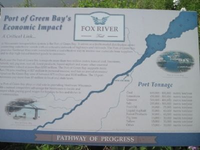
Port of Green Bay's Economic Impact
A Critical Link...
ó Fox River Trail ó
in Wisconsinís transportation system is the Port of Green Bay. It serves as a multi-modal distribution center connecting waterborne vessels with an extensive network of highways and railroads. The Port of Green Bay provides Northeast Wisconsin manufacturers a cost-effective way to receive raw materials from suppliers and to ship high-valued finished goods to customers.
Each year the Port of Green Bay transports more than 2 million metric tons of coal, limestone, cement, salt, pig iron, fuel oil, forest products, liquid asphalt and many other essential commodities valued at more than $300 million. The Port of Green Bay supports more than 700 jobs resulting in $27 million in personal income, and has an annual economic impact on the Green Bay area of between $75 million and $100 million. The 13 port businesses pay more than $5 million in local and state taxes.
The Port of Green Bay plays a vital role in providing Northeast Wisconsin with a natural competitive advantage for businesses to locate and prosper while paying good wages for families to live and thrive in our communities.
Port Tonnage
Coal 600,000 - 800,000 metric ton/year
Limestone 450,000 - 500,000 metric ton/year
Cement 300,000 - 400,000 metric ton/year
Salt 200,000 - 300,000 metric ton/year
Fuel Oil 30,000 - 75,000 metric ton/year
Liquid Asphalt 30,000 - 60,000 metric ton/year
Forest Products 30,000 - 60,000 metric ton/year
Pig Iron 15,000 - 30,000 metric ton/year
Tallow 15,000 - 30,000 metric ton/year
Other 15,000 - 30,000 metric ton/year
Topics. This historical marker is listed in these topic lists: Industry & Commerce • Waterways & Vessels.
Location. 44° 30.05′ N, 88° 1.231′ W. Marker is in Green Bay, Wisconsin, in Brown County. Marker can be reached from the intersection of Eliza Street and South Madison Street. Located on the Fox River Trail. Touch for map. Marker is in this post office area: Green Bay WI 54301, United States of America. Touch for directions.
Other nearby markers. At least 8 other markers are within walking distance of this marker. Hazelwood (here, next to this marker); a different marker also named Hazelwood (a few steps from this marker); First Catholic Church In Green Bay (approx. half a mile away); La Baye Burial Place (approx. half a mile away); Bank Of Wisconsin (approx. 0.6 miles away); Elks Club (approx. 0.7 miles away); Milwaukee Road Passenger Depot (approx. 0.7 miles away); Milwaukee Road Depot (approx. 0.7 miles away). Touch for a list and map of all markers in Green Bay.
Related markers. Click here for a list of markers that are related to this marker.
Also see . . .
1. Port of Green Bay. Brown County (Submitted on June 26, 2011, by Bernard Fisher of Richmond, Virginia.)
2. Fox River Trail. (Submitted on June 27, 2011, by Bernard Fisher of Richmond, Virginia.)
Credits. This page was last revised on June 16, 2016. It was originally submitted on June 26, 2011, by Bob (peach) Weber of Dewey, Arizona. This page has been viewed 844 times since then and 24 times this year. Last updated on June 27, 2011, by Bob (peach) Weber of Dewey, Arizona. Photos: 1, 2, 3. submitted on June 26, 2011, by Bob (peach) Weber of Dewey, Arizona. • Bernard Fisher was the editor who published this page.


