Near Brandy Station in Culpeper County, Virginia — The American South (Mid-Atlantic)
The Battle of Brandy Station
Surprises at the Crossing
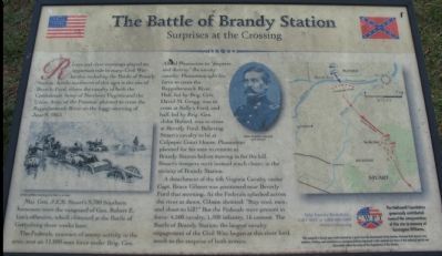
Maj. Gen. J.E.B. Stuart's 9,700 Southern horsemen were the vanguard of Gen. Robert E. Lee's offensive, which climaxed at the Battle of Gettysburg three weeks later.
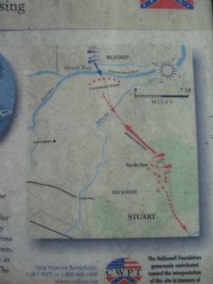
The Federals, unaware of enemy activity in the area; sent an 11,000-man force under Brig. Gen. Alfred Pleasonton to "disperse and destroy" the enemy cavalry. Pleasonton split his force to cross the Rappahannock River. Half, led by Brig. Gen. David M. Gregg, was to cross at Kelly's Ford, and half, led by Brig. Gen. John Buford, was to cross at Beverly Ford. Believing Stuart's cavalry to be at Culpeper Court House, Pleasonton planned for his men to reunite at Brandy Station before moving in for the kill. Stuart's troopers were instead much closer, in the vicinity of Brandy Station.
A detachment of the 6th Virginia Cavalry under Capt. Bruce Gibson was positioned near Beverly Ford that morning. As the Federals splashed across the river at dawn, Gibson shouted: "Stay cool, men, and shoot to kill!" But the Federals were present in force: 4,500 cavalry, 1,500 infantry, 16 cannon. The Battle of Brandy Station, the single largest cavalry engagement of the Civil War, began at this river ford much to the surprise of both armies.
Help Preserve Battlefields • call CWPT at 1-888-606-1400 • www.civilwar.org • The Hallowell Foundation generously contributed toward the interpretation of this site in memory of Carrington Williams.
This material is based upon work assisted by a grant from the Department of the Interior, National Park Service. Any opinion, findings and conclusions or recommendations expressed in this material are those of the author(s) and do not necessarily reflect the views of the Department of the Interior.
Erected by Civil War Preservation Trust.
Topics. This historical marker is listed in this topic list: War, US Civil. A significant historical date for this entry is June 9, 1863.
Location. 38° 32.024′ N, 77° 51.439′ W. Marker is near Brandy Station, Virginia, in Culpeper County. Marker is on Beverly Ford Road (County Route 676), on the right when traveling north. Located at the second trail stop for the Buford's Knoll Walking Trail of the the Battle of Brandy Station. Touch for map. Marker is in this post office area: Brandy Station VA 22714, United States of America. Touch for directions.
Other nearby markers. At least 8 other markers are within walking distance of this marker. A different marker also named The Battle of Brandy Station
More about this marker. On the left of the marker is a drawing of "Union artillery crossing at a ford in a river." A portrait of Union Brigadier General John Buford is in the center. On the right is a topographical map with positions of the major units and their movements, described on the text.
Regarding The Battle of Brandy Station. This is one of several markers interpreting the Battle of Brandy Station and the winter encampments of 1863-64 in Culpeper County. See the Battle of Brandy Station Virtual Tour by Markers linked below for additional related markers.
Also see . . .
1. Battle of Brandy Station. National Park Service guide to the battle, including a driving tour. (Submitted on December 28, 2007, by Craig Swain of Leesburg, Virginia.)
2. Brandy Station Foundation. Through the efforts of the Brandy Station Foundation, Civil War Preservation Trust, and other organizations, over 960 acres of this battlefield have been preserved. (Submitted on December 28, 2007, by Craig Swain of Leesburg, Virginia.)
3. Brandy Station. Civil War Preservation Trust classroom article on the battle. (Submitted on December 30, 2007, by Craig Swain of Leesburg, Virginia.)
4. Battle of Brandy Station Virtual Tour by Markers. A set markers that document the Battle of Brandy Station, June 9, 1863, and the Winter Encampment of 1863-64. Note the order of appearance is geographic and not chronologically aligned to the battle. (Submitted on January 1, 2008, by Craig Swain of Leesburg, Virginia.)

Photographed By Craig Swain, December 22, 2007
5. Approaches to Beverly Ford
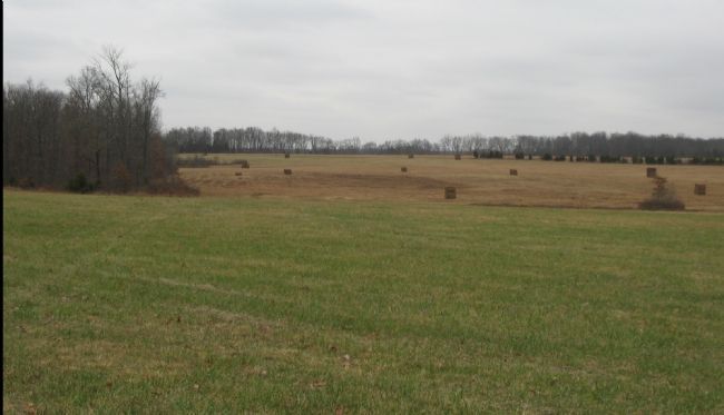
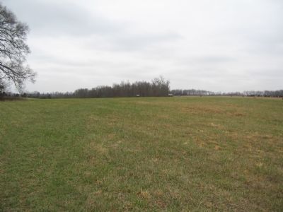
Looking northeast from the marker location, the tall trees in the background are along Ruffans Run. The Beverly Ford road runs from the right of the photo along the edge of the field in the foreground. The location of the Ford is further to the north and currently on privately held property and is inaccessible.
Credits. This page was last revised on August 3, 2022. It was originally submitted on December 28, 2007, by Craig Swain of Leesburg, Virginia. This page has been viewed 1,934 times since then and 26 times this year. Last updated on August 1, 2022, by Carl Gordon Moore Jr. of North East, Maryland. Photos: 1. submitted on December 28, 2007, by Craig Swain of Leesburg, Virginia. 2. submitted on March 13, 2009, by Craig Swain of Leesburg, Virginia. 3, 4, 5. submitted on December 28, 2007, by Craig Swain of Leesburg, Virginia. • Bernard Fisher was the editor who published this page.


