Near Culpeper in Culpeper County, Virginia — The American South (Mid-Atlantic)
The Battle of Cedar Mountain
August 9, 1862
Help Preserve Battlefields, Call CWPT at 1-888-606-1400
Friends of Fredericksburg Area Battlefields - www.fofab.org
This material is based upon work assisted by a grant from the Department of the Interior, National Park Service. Any opinions, findings and conclusions or recommendations expressed in this material are those of the author(s) and do not necessarily reflect the views of the Department of the Interior.
Erected by Civil War Preservation Trust
Friends of Fredericksburg Area Battlefields.
Topics and series. This historical marker is listed in this topic list: War, US Civil. In addition, it is included in the Battlefield Trails - Civil War series list. A significant historical date for this entry is August 9, 1862.
Location. Marker has been permanently removed. It was located near 38° 24.309′ N, 78° 4.113′ W. Marker was near Culpeper, Virginia, in Culpeper County. Marker was at the intersection of General Winder Road (County Route 657) and James Madison Highway (U.S. 15), on the right when traveling west on General Winder Road. Located at the pull-off and trail head for the Civil War Preservation Trust's Cedar Mountain Battlefield walking trail. Touch for map. Marker was in this post office area: Culpeper VA 22701, United States of America.
We have been informed that this sign or monument is no longer there and will not be replaced. This page is an archival view of what was.
Other nearby markers. At least 8 other markers are within walking distance of this location. A different marker also named The Battle of Cedar Mountain (a few steps from this marker); a different marker also named
Photographed By Craig Swain, December 22, 2007
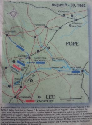
2. Second Manassas Campaign Map
Key to map:
1. General Stonewall Jackson's Confederate army defeats General Nathaniel Banks' Federals at the Battle of Cedar Mountain on August 9. 2. Jackson retired south on August 11 after learning of the Union army converging on Culpeper. 3. General Robert E. Lee orders the rest of his army toward Gordonsville on August 13 and 4. consolidates his forces at Clark's Mountain on August 16. 5. General John Pope realizes that the Confederates are concentrating in his front and withdraws from Culpeper to a position along the Rappahannock River on August 18. 6. On August 27, Pope discovers Jackson in his rear and concentrates the Union army on Manassas Junction and 7. setting the stage for the Second Battle of Manassas on August 18 through 30.
1. General Stonewall Jackson's Confederate army defeats General Nathaniel Banks' Federals at the Battle of Cedar Mountain on August 9. 2. Jackson retired south on August 11 after learning of the Union army converging on Culpeper. 3. General Robert E. Lee orders the rest of his army toward Gordonsville on August 13 and 4. consolidates his forces at Clark's Mountain on August 16. 5. General John Pope realizes that the Confederates are concentrating in his front and withdraws from Culpeper to a position along the Rappahannock River on August 18. 6. On August 27, Pope discovers Jackson in his rear and concentrates the Union army on Manassas Junction and 7. setting the stage for the Second Battle of Manassas on August 18 through 30.
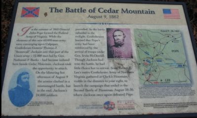
More about this marker. On the lower left is a portrait of "Union Major General John Pope" who "led the newly formed Army of Virginia during the summer of 1862." In the upper center is a portrait of Confederate General "Stonewall" Jackson. A Second Manassas Campaign map is on the right side of the marker with important phases of the operation highlighted.
Regarding The Battle of Cedar Mountain. This is one
of several markers interpreting the Battle of Cedar Mountain. See the Battle of Cedar Mountain Virtual Tour by Markers linked below.
Related markers. Click here for a list of markers that are related to this marker. A Virtual Tour by Markers of the Battle of Cedar Mountain
Also see . . . Friends of the Fredericksburg Area Battlefields. The current home page for the FOFAB. The URL listed on the marker is now invalid. (Submitted on December 31, 2007, by Craig Swain of Leesburg, Virginia.)
Photographed By Craig Swain, December 22, 2007
4. The Battle of Cedar Mountain
The Walking Trail
The Walking Trail
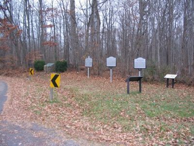
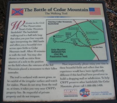
Standing nearby at the bend of General Winder Road, is the trail head for the Cedar Mountain trail:
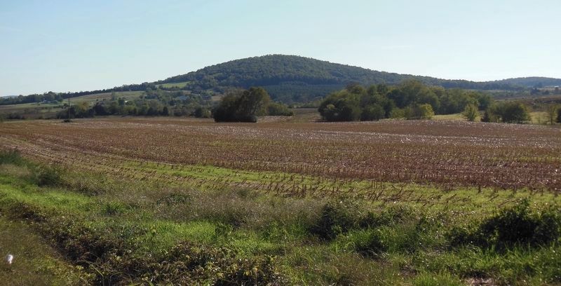
Welcome to the Civil War Preservation Trust's Cedar Mountain Battlefield! The battlefield walking trail is a half-mile loop that takes you past four wayside signs interpreting the 1862 battle and offers you a beautiful view across open fields to Cedar Mountain itself. Allow 45 minutes to walk the trail. You may also choose to walk an extra three quarters of a mile to the position on the field where the veterans of the 3rd Wisconsin placed a monument to their fallen comrades.
The trail is surfaced with mown grass, so be careful of the irregular surface and watch for snakes. Please do not stray from the trail as, at times, it takes you very near CWPT's property line. Be respectful of private property and do not trespass.
Most importantly, please enjoy your time in these beautiful fields and reflect that this experience would have been significantly different if this land had been paved over to build a shopping mall or subdivision. To help CWPT preserve other battlefields like Cedar Mountain, please call 1-800-606-1400.
Photographed By Craig Swain, December 22, 2007
5. Trail Map
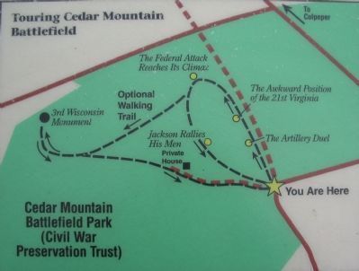
The start of the trail (indicated by the "you are here" star) is the approximate location of Crittenden Gate, at the bend in General Winder Road (CR 657). Note also the roadbed for the original Orange and Culpeper ran parallel to the modern day James Madison Highway (US. 15) at this point, and is shown with a dashed brown line on the map extending to the north (top of map). Crittenden Lane ran from the bend in the road, along modern CR 657, to the south towards Cedar Mountain.
Credits. This page was last revised on October 21, 2021. It was originally submitted on December 31, 2007, by Craig Swain of Leesburg, Virginia. This page has been viewed 2,562 times since then and 25 times this year. Last updated on October 16, 2021, by Bradley Owen of Morgantown, West Virginia. Photos: 1, 2. submitted on December 31, 2007, by Craig Swain of Leesburg, Virginia. 3. submitted on December 30, 2007, by Craig Swain of Leesburg, Virginia. 4, 5. submitted on January 1, 2008, by Craig Swain of Leesburg, Virginia. 6. submitted on March 16, 2021, by Bradley Owen of Morgantown, West Virginia. • Bernard Fisher was the editor who published this page.
