Near Culpeper in Culpeper County, Virginia — The American South (Mid-Atlantic)
The Battle of Cedar Mountain
The Awkward Position of the 21st Virginia
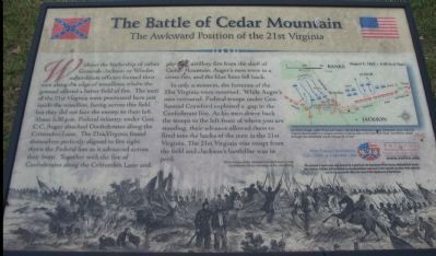
In only a moment, the fortunes of the 21st Virginia were reversed. While Auger's men retreated, Federal troops under Gen. Samuel Crawford exploited a gap in the Confederate line. As his men drove back the troops to the left-front of where you are standing, their advance allowed them to fired into the backs of the men in the 21st Virginia. The 21st Virginia was swept from the field and Jackson's battle line was in peril.
Help Preserve Battlefields, Call CWPT at 1-888-606-1400
Friends of Fredericksburg Area Battlefields - www.fofab.org
This material is based upon work assisted by a grant from the Department of the Interior, National Park Service. Any opinions, findings and conclusions or recommendations expressed in this material are those of the author(s) and do not necessarily reflect the views of the Department of the Interior.
Erected by Civil War Preservation Trust
Friends of Fredericksburg Area Battlefields.
Topics. This historical marker is listed in this topic list: War, US Civil.
Location. Marker has been permanently removed. It was located near 38° 24.369′ N, 78° 4.014′ W. Marker was near Culpeper, Virginia, in Culpeper County. Marker could be reached from the intersection of General Winder Road (County Route 657) and James Madison Highway (U.S. 15), on the right when traveling west. Located at the second trail stop for the Civil War Preservation Trust's Cedar Mountain Battlefield walking trail. Touch for map. Marker was in this post office area: Culpeper VA 22701, United States of America.
We have been informed that this sign or monument is no longer there and will not be replaced. This page is an archival view of what was.
Other nearby markers. At least 8 other markers are within walking distance of this location. A different marker also named Battle of Cedar Mountain (within shouting distance of this marker); a different marker also named Battle of Cedar Mountain (about 300 feet away, measured in a direct line); a different marker also named Battle of Cedar Mountain (about 400 feet away); a different marker also named Battle of Cedar Mountain (about 500 feet away); a different marker also named The Battle of Cedar Mountain (about 600 feet away); a different marker also named Battle of Cedar Mountain (about 600 feet away); Hand-to-Hand Fighting (about 700 feet away); a different marker also named Battle of Cedar Mountain (about 700 feet away). Touch for a list and map of all markers in Culpeper.
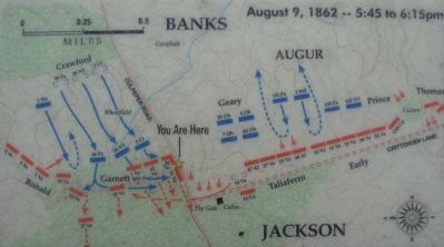
More about this marker. The background of the marker is a drawing depicting "Union troops under General Crawford overrun the Confederate left on the edge of the wheatfield." A map in the upper right shows the tactical situation on August 9, 1862 between 5:45 and 6:15 p.m. "As Union troops under Prince and Geary attacked Confederates along Crittenden Lane, the 21st Virginia found itself in a unique position of being able to fire into their
flank. Crawford's attack through the wheatfield would change all of that."
Regarding The Battle of Cedar Mountain. Since posting of this marker, the Friends of the Fredericksburg Area Battlefields web site has moved to www.parksonline.org/fofab/index.htm.
This is one of several markers interpreting the Battle of Cedar Mountain. See the Battle of Cedar Mountain Virtual Tour by Markers linked below.
Also see . . .
1. Battle of Cedar Mountain. National Park Service summary of the battle and driving tour. The marker is at the first tour stop. (Submitted on December 31, 2007, by Craig Swain of Leesburg, Virginia.)
2. History of F Company, 21st Virginia. One of the notable members of the company was John Worsham who wrote One of Jackson's Foot Cavalry, considered one of the classic soldier's accounts of the Civil War. Company F, which began the war with well over 100 men had been reduced to eighteen by the time of the Battle of Cedar Mountain. Of those, six were killed and six wounded during the fighting on August 9, 1862. (Submitted on January 1, 2008, by Craig Swain of Leesburg, Virginia.)
3. Battle of Cedar Mountain Virtual Tour by Markers. A set markers that document the Battle of Cedar Mountain, August 9, 1862. (Submitted on January 1, 2008, by Craig Swain of Leesburg, Virginia.)
Additional commentary.
1. Garnett's Brigade
The brigade to which the 21st Virginia belonged was the 2nd Brigade of Jackson's Division. The division gained the name "Stonewall Division" after service in the Valley Campaign under the command of General T. J. "Stonewall" Jackson. After the Seven Days Campaign, and Jackson promoted to command a corps, General Charles Winder was promoted to command the division.
Col. T. S. Garnett commanding the brigade here was not the more famous Richard B. Garnett (whom had commanded another brigade in the division until a dispute with General Jackson after the Battle of Kernstown precipitated his resignation). Col. T. S. Garnett would be killed in action nearly two years later at the Battle of the Wilderness.
The brigade consisted of the 21st, 42nd, and 48th Virginia Infantry Regiments. In addition the 1st Virginia Infantry Battalion, a separate, un-regimented organization comprised of ethnic Irish and Scotch-Irish, served in the brigade.
— Submitted January 1, 2008, by Craig Swain of Leesburg, Virginia.
Photographed By Craig Swain, December 22, 2007
5. The 21st Virginia's View of Augur's Attack
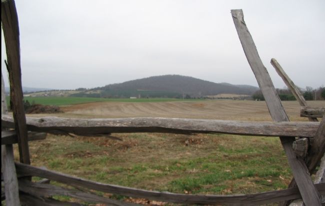
Augur's and Geary's men advanced across the field to the front here, beyond the fence, towards Crittenden Lane on the right side of the photo. Clearly apparent from this view is the cross fire described on the marker. With the artillery on the shelf of Cedar Mountain (dark green stand of trees on the mountain) firing from the east, Early and Taliaferro's men firing from the south (the present day General Winder Road, right of photo), and the 21st Virgina firing adding their fire from behind this fence, the Federals were hit on three sides.
Photographed By Craig Swain, December 22, 2007
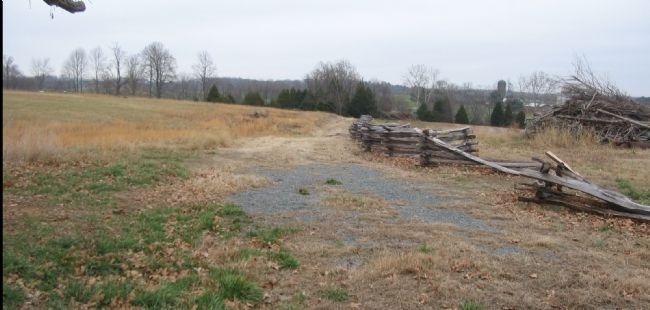
6. Old Road Bed and Garnett's Brigade Line
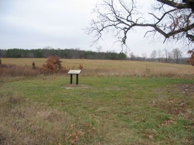
At the time of the battle the area to the right of the fence line was open field, and the Orange and Culpeper Road ran along the fence. The ground to the left of the fence (including the center foreground) was wooded. About where the gravel path ends here, a farm lane intersected the road and extended to the west (to the left). The 48th Virginia Infantry defended here, at an apex, to the left of the 21st Virginia. The 42nd Virginia and the 1st Virginia Battalion extended the Confederate lines about 100 to 200 yards to the west (running out of the photo to the left) of the 48th, into the woods. But the left flank at that point was not protected. Furthermore, the 48th, 42nd, and 1st Battalion were all posted within the woods with no clear fields of fire or view of approaching enemy troops. Crawford's Federals hit at this vulnerable spot and turned the exposed flank.
Credits. This page was last revised on October 21, 2021. It was originally submitted on December 31, 2007, by Craig Swain of Leesburg, Virginia. This page has been viewed 3,302 times since then and 17 times this year. Last updated on October 16, 2021, by Bradley Owen of Morgantown, West Virginia. Photos: 1. submitted on December 31, 2007, by Craig Swain of Leesburg, Virginia. 2. submitted on March 30, 2009, by Craig Swain of Leesburg, Virginia. 3, 4. submitted on December 31, 2007, by Craig Swain of Leesburg, Virginia. 5, 6. submitted on January 1, 2008, by Craig Swain of Leesburg, Virginia. • Bernard Fisher was the editor who published this page.
